


Looking for the perfect holiday gift for a planner? Check out these new map books.

Joshua Hammer reviews four coffee-table treasures that illustrate the many entertaining and intellectual cartographic forms.
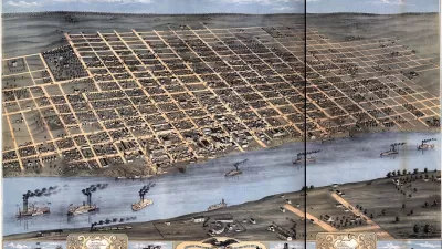
Map: Exploring the World is a collection of 300 celebrated maps spanning 3,000 years: "the most captivating of several new books that explore the power of spatial representations and how they shape our perceptions of reality," according to Hammer.
The Curious Map Book explores the more playful side of maps, with illustrations of puzzles from 18th century Britain, hand-woven rugs from wartime Afghanistan, and Hammer's favorite—a series of anthropomorphic satires. Among these "one exquisite creation, drawn by the lithographic artist and caricaturist Joseph John Goggins, probably in Dublin, in 1870, [that] portrays Europe as a menagerie of grotesque humans and beasts in sometimes bellicose poses."
In his book, Restless Empire: A Historical Atlas of Russia, Ian Barnes narrates a cartographic history of Russia and the Soviet Empire. "Most powerful are his maps of the wars that repeatedly threatened to tear the empire apart, from Napoleon’s doomed invasion in 1812 to Hitler’s Operation Barbarossa in 1941," opines Hammer.
Tim Marshall's ambitious claim to explain everything about the world in ten maps (Prisoners of Geography: Ten Maps That Explain Everything About the World) may seem at times reductionist. However, Hammer finds that Marshall's "insistence on seeing the world through the lens of geography compels a fresh way of looking at maps — not just as objects for orientation or works of art, but as guideposts to the often thorny relations between nations."
FULL STORY: ‘Map: Exploring the World,’ ‘The Curious Map Book’ and More

Mapped: Every Building in the United States
Using data from Microsoft, the New York Times has published an online map showing the placement of every building in the country, in a simple black and white format.
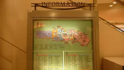
The Future of Mapping is Going Indoors
Cartographers have a new world to map, as technology opens up the interiors of malls, museums, and other large spaces to online exploration.
Today's Cartographers Are Database Engineers
Modern maps are visual representations of millions of points of standardized data.

Planetizen Federal Action Tracker
A weekly monitor of how Trump’s orders and actions are impacting planners and planning in America.

Maui's Vacation Rental Debate Turns Ugly
Verbal attacks, misinformation campaigns and fistfights plague a high-stakes debate to convert thousands of vacation rentals into long-term housing.

San Francisco Suspends Traffic Calming Amidst Record Deaths
Citing “a challenging fiscal landscape,” the city will cease the program on the heels of 42 traffic deaths, including 24 pedestrians.

Amtrak Rolls Out New Orleans to Alabama “Mardi Gras” Train
The new service will operate morning and evening departures between Mobile and New Orleans.

The Subversive Car-Free Guide to Trump's Great American Road Trip
Car-free ways to access Chicagoland’s best tourist attractions.

San Antonio and Austin are Fusing Into one Massive Megaregion
The region spanning the two central Texas cities is growing fast, posing challenges for local infrastructure and water supplies.
Urban Design for Planners 1: Software Tools
This six-course series explores essential urban design concepts using open source software and equips planners with the tools they need to participate fully in the urban design process.
Planning for Universal Design
Learn the tools for implementing Universal Design in planning regulations.
Heyer Gruel & Associates PA
JM Goldson LLC
Custer County Colorado
City of Camden Redevelopment Agency
City of Astoria
Transportation Research & Education Center (TREC) at Portland State University
Jefferson Parish Government
Camden Redevelopment Agency
City of Claremont