


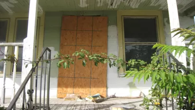
The Innovation Team in Mobile shows that sometimes innovation can be delivered through commonplace technology.
J.B. Wogan reports on the surprisingly low-cost solution developed in Mobile, Alabama: using the image and mapping capabilities of the popular social media app Instagram to make an initial survey of the city's blighted properties.
After receiving a $1.65 million grant last December as one of the Bloomberg Philanthropies "Innovation Teams," Joan Dunlap and her team in Mobile was able to implement Instagram at no cost to fill a badly needed survey need to begin to document the location and scale of the city's blighted properties:
"The city could create an account and send code enforcement officers to take photos of blighted properties. The app would automatically document the general location of the photo and its mapping function allowed the mayor’s team to see where the biggest concentrations of blight were. Unlike the 311 call data, it was easily accessible from any workers’ computer and could be updated as officers found more properties."
In effect, Instagram helped kick start the effort by gathering data that the city previously could not access. After the initial, Instagram-enabled survey, the Mobile's Geographic Information Systems department provided "a better app that allows [code enforcement] to pinpoint the exact locations of each property." In the end, the city was able to collect data and begin to build a strategy for mitigating 1,256 blighted properties, according to Wogan.
FULL STORY: How Mobile, Alabama, Used Instagram to Address Blight

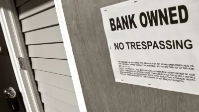
In Mobile, an Institutional Revamp to Tackle Blight
Mobile, Alabama, has changed the way it deals with blight, and the results have been substantial.
12 Cities Awarded 'Innovation Delivery Team' Grants from Bloomberg Philanthropies
After announcing a first round of grants in August, Bloomberg Philanthropies expanded its $45 million innovation teams program to 12 cities in the United States and two abroad.
From Vacant Property to Affordable Housing Development
The city of St. Petersburg provides a model for transforming blight to a blessing.

Trump Administration Could Effectively End Housing Voucher Program
Federal officials are eyeing major cuts to the Section 8 program that helps millions of low-income households pay rent.

Planetizen Federal Action Tracker
A weekly monitor of how Trump’s orders and actions are impacting planners and planning in America.

Canada vs. Kamala: Whose Liberal Housing Platform Comes Out on Top?
As Canada votes for a new Prime Minister, what can America learn from the leading liberal candidate of its neighbor to the north?

Wildlife Rebounds After the Eaton Fire
Following the devastation of the Eaton Fire, the return of wildlife and the regrowth of native plants are offering powerful signs of resilience and renewal.

LA to Replace Inglewood Light Rail Project With Bus Shuttles
LA Metro says the change is in response to community engagement and that the new design will be ready before the 2028 Olympic Games.

Paris Voters Approve More Car-Free Streets
Paris Mayor Anne Hidalgo says the city will develop a plan to close 500 streets to car traffic and add new bike and pedestrian infrastructure after a referendum on the proposal passed with 66 percent of the vote.
Urban Design for Planners 1: Software Tools
This six-course series explores essential urban design concepts using open source software and equips planners with the tools they need to participate fully in the urban design process.
Planning for Universal Design
Learn the tools for implementing Universal Design in planning regulations.
Central Transportation Planning Staff/Boston Region MPO
Heyer Gruel & Associates PA
Institute for Housing and Urban Development Studies (IHS)
City of Grandview
Harvard GSD Executive Education
Toledo-Lucas County Plan Commissions
Salt Lake City
NYU Wagner Graduate School of Public Service