


Jody Avirgan shares insight into a new podcast with the creators of the new Pixar movie The Good Dinosaur, which reads like more of an advertisement for the U.S. Geological Survey (USGS).
A 30-minute "What's the Point" podcast puts host Jody Avirgan in conversation with David Munier, set supervisor for the new Pixar film The Good Dinosaur. A clip introducing the podcast quotes Munier describing the environment as the antagonist in the film, requiring a higher degree of realism than a completely fantasy world often offers. Avirgan describes the role of the USGS in making the landscapes come to life:
"Pixar used actual U.S. Geological Survey information to render the landscapes that Arlo and Spot (the titular dinosaur and his pet human) traipse around in. This data allowed the animators to re-create actual mountains, streams and horizons, which in turn let director Pete Sohn compose the wide-open shots he was looking for."
Part of the podcast's fascination with the film is the amount of data that the film used—one scene, for instance, used as much data as the entirety of the 2011 film Cars 2.
Also included in the podcast is a conversation between Derrick Clements of "The Pixar Podcast" and Mike Tischler, director of the USGS National Geospatial Program, about how the USGS gathers data.
FULL STORY: The Dream World Of ‘The Good Dinosaur’ Is Based On USGS Surveys


USGS Water Science Centers Targeted for Closure
If their work is suspended, states could lose a valuable resource for monitoring, understanding, and managing water resources.
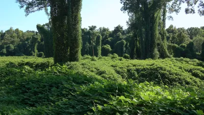
Finding New Uses for the 'Vine That Ate the South'
Visually striking and aggressively invasive, kudzu has been choking the Southeast for decades. Now, designers, chefs, and activists want to find ways to make it useful.
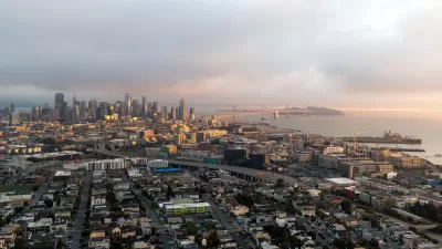
Where the Ground Sinks Under the Weight of Development
New research documents how the weight of buildings causes the ground to sink underneath developments in the San Francisco Bay Area.

Planetizen Federal Action Tracker
A weekly monitor of how Trump’s orders and actions are impacting planners and planning in America.

Congressman Proposes Bill to Rename DC Metro “Trump Train”
The Make Autorail Great Again Act would withhold federal funding to the system until the Washington Metropolitan Area Transit Authority (WMATA), rebrands as the Washington Metropolitan Authority for Greater Access (WMAGA).

The Simple Legislative Tool Transforming Vacant Downtowns
In California, Michigan and Georgia, an easy win is bringing dollars — and delight — back to city centers.

The States Losing Rural Delivery Rooms at an Alarming Pace
In some states, as few as 9% of rural hospitals still deliver babies. As a result, rising pre-term births, no adequate pre-term care and "harrowing" close calls are a growing reality.

The Small South Asian Republic Going all in on EVs
Thanks to one simple policy change less than five years ago, 65% of new cars in this Himalayan country are now electric.

DC Backpedals on Bike Lane Protection, Swaps Barriers for Paint
Citing aesthetic concerns, the city is removing the concrete barriers and flexposts that once separated Arizona Avenue cyclists from motor vehicles.
Urban Design for Planners 1: Software Tools
This six-course series explores essential urban design concepts using open source software and equips planners with the tools they need to participate fully in the urban design process.
Planning for Universal Design
Learn the tools for implementing Universal Design in planning regulations.
Smith Gee Studio
City of Charlotte
City of Camden Redevelopment Agency
City of Astoria
Transportation Research & Education Center (TREC) at Portland State University
US High Speed Rail Association
City of Camden Redevelopment Agency
Municipality of Princeton (NJ)