


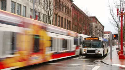
With a light rail network now reaching 60 miles, the Portland region is ready to explore its next regional transit options.
A "sponsored" post by Metro is running on The Oregonian's website. The post provides an overview of two large planning efforts currently underway in the region.
The first, the Southwest Corridor Plan, which will combine the efforts of the corridor's seven cities, Metro, TriMet and ODOT "to decide whether to continue studying a transit line from downtown Portland to Tigard and possibly Tualatin." Moreover, "[t]hey'll also decide whether to extend the MAX light rail network into the corridor or use something called Bus Rapid Transit, which uses high-tech buses, sometimes in their own travel lanes, to provide faster, more reliable transit service."
The second planning effort will focus its efforts toward the eastern side of the region, where the Powell-Division Transit and Development Project is in need of a final route for bus rapid transit line that will connect Portland State University, Oregon Health and Science University, the Oregon Museum of Science and Industry, and two community colleges. That line is targeted for a 2020 opening date.
Echoing a tweet by Jarrett Walker, it's hard to digest all this big planning news without wondering why Metro has to sponsor a post about the transportation future of the city. Everything included in the post seems like news the Oregonian should find a better way to report, given its importance and value to residents of the region and the damaging perception of news reported in advertorial fashion.
FULL STORY: After the Orange Line: Region's leaders look to serve more people with fast transit


New Details for Portland's Transit Plan as Voters Head to the Polls
Voters in Portland-area voters will decide on a transportation funding measure for the "Get Moving 2020" plan, with details of four bus rapid transit project targeted for funding announced within weeks of the election.
When 'Bus Rapid Transit' Slows Buses, Portland Goes Back to the Drawing Board
Michael Andersen reports on the evolving Powell-Division Transit and Development Project, recently revealed to fall short of its intended goal to speed up bus service in the planning area.
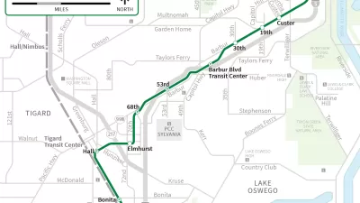
Portland Transit Vote Kills SW Transit Corridor Light Rail Project
In a pair of articles, Jonathan Maus reports on the final moments of the SW Corridor Light Rail Project, as project supporters deals with a loss at the ballot box.

Maui's Vacation Rental Debate Turns Ugly
Verbal attacks, misinformation campaigns and fistfights plague a high-stakes debate to convert thousands of vacation rentals into long-term housing.

Planetizen Federal Action Tracker
A weekly monitor of how Trump’s orders and actions are impacting planners and planning in America.

Chicago’s Ghost Rails
Just beneath the surface of the modern city lie the remnants of its expansive early 20th-century streetcar system.

Bend, Oregon Zoning Reforms Prioritize Small-Scale Housing
The city altered its zoning code to allow multi-family housing and eliminated parking mandates citywide.

Amtrak Cutting Jobs, Funding to High-Speed Rail
The agency plans to cut 10 percent of its workforce and has confirmed it will not fund new high-speed rail projects.

LA Denies Basic Services to Unhoused Residents
The city has repeatedly failed to respond to requests for trash pickup at encampment sites, and eliminated a program that provided mobile showers and toilets.
Urban Design for Planners 1: Software Tools
This six-course series explores essential urban design concepts using open source software and equips planners with the tools they need to participate fully in the urban design process.
Planning for Universal Design
Learn the tools for implementing Universal Design in planning regulations.
planning NEXT
Appalachian Highlands Housing Partners
Mpact (founded as Rail~Volution)
City of Camden Redevelopment Agency
City of Astoria
City of Portland
City of Laramie