


Urban Kchoze presents a detailed, step-by-step analysis of the relationship between commercial density and residential density to find a better understanding of which matters more for promoting walkability.

"[W]alkability is usually measured not by how many people reside near you, but by how many services and shops you can access from where you live," according to a post on the blog Urban Khoze. "So to achieve great walkability, it seems that commercial density is very important." Metrics like Walk Score exemplify this claim, but this post takes a look under the hood, so to speak, by examining a model for proof that commercial density is even more important than residential density in achieving the goals of walkability.
The post begins by examining the example set by old American cities, where commercial buildings cover the entire lot and floor-to-area ratio of 150 percent to 250 percent. That density, however, often times clashes with residential densities just a few blocks away, with FAR in the realm of 25 percent to 30 percent. The lesson from these types of arrangements: "So old American cities had very high commercial densities on main street but relatively low densities in residential areas. And we know these small towns were walkable because they were built in an era where cars were still relatively rare, if not even before, when they didn't exist."
Following some of the implications of that example, the post goes on to set up a model with four scenarios of commercial and residential arrangement to reveal more insight into the importance of density in their relationship. The post's exploration of each of these scenarios informs many concepts that are helpful in understanding planning to improve walkability. The conclusion: "achieving commercial density is far more important to re-establishing walkable cities than densifying residential areas."
FULL STORY: Urban Kchoze


Opinion: What San Francisco’s Proposed ‘Family Zoning’ Could Really Mean
Mayor Lurie is using ‘family zoning’ to encourage denser development and upzoning — but could the concept actually foster community and more human-scale public spaces?
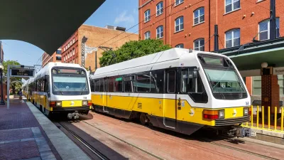
North Texas Transit Leaders Tout Benefits of TOD for Growing Region
At a summit focused on transit-oriented development, policymakers discussed how North Texas’ expanded light rail system can serve as a tool for economic growth.

California Bill Aims to Boost TOD
A bill proposed by Sen. Scott Wiener would exempt transit agencies from zoning rules near ‘high-quality’ transit stops and allow denser transit-oriented development.

Planetizen Federal Action Tracker
A weekly monitor of how Trump’s orders and actions are impacting planners and planning in America.

Chicago’s Ghost Rails
Just beneath the surface of the modern city lie the remnants of its expansive early 20th-century streetcar system.

San Antonio and Austin are Fusing Into one Massive Megaregion
The region spanning the two central Texas cities is growing fast, posing challenges for local infrastructure and water supplies.

Since Zion's Shuttles Went Electric “The Smog is Gone”
Visitors to Zion National Park can enjoy the canyon via the nation’s first fully electric park shuttle system.

Trump Distributing DOT Safety Funds at 1/10 Rate of Biden
Funds for Safe Streets and other transportation safety and equity programs are being held up by administrative reviews and conflicts with the Trump administration’s priorities.

German Cities Subsidize Taxis for Women Amid Wave of Violence
Free or low-cost taxi rides can help women navigate cities more safely, but critics say the programs don't address the root causes of violence against women.
Urban Design for Planners 1: Software Tools
This six-course series explores essential urban design concepts using open source software and equips planners with the tools they need to participate fully in the urban design process.
Planning for Universal Design
Learn the tools for implementing Universal Design in planning regulations.
planning NEXT
Appalachian Highlands Housing Partners
Mpact (founded as Rail~Volution)
City of Camden Redevelopment Agency
City of Astoria
City of Portland
City of Laramie