


While standardized metrics for determining the number of and place for city parks cannot replace more fine grain analysis, they can be useful tools. Park planner Clement Lau writes about five park-need metrics, including a couple of the newest.
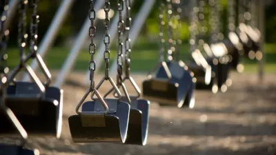
Standardized park planning metrics that prescribe, for example, x acres of park per 1,000 residents, have a bad rap. However, planners cannot rely solely on subjective input. Standardized metrics are an invaluable tool for planners when not blindly implemented. Park planner Clement Lau reviews five valuable metrics, including a couple of the newest, which work best when integrated with other metrics and more fine grain analysis. Excerpts of his review are as follows:
Park Acres per 1,000 Residents
This is a commonly used indicator of the amount of parkland available in a given area.
. . .
Park Accessibility
This metric is evaluated by using a Geographic Information System (GIS) and Census data to determine the percentage of households that are within walking distance from a park.
. . .
Park Pressure
Park pressure is a lesser known, but helpful metric that refers to the potential demand on a park, assuming that the residents in a “parkshed” use the park closest to them.
. . .
Quantity and Variety of Park Amenities
It should be obvious that not all parks are created equal and that the quantity and variety of amenities vary widely.
. . .
Condition of Park Amenities
The condition or quality of park amenities is a key measure of park adequacy. . . . The condition of this infrastructure and park amenities may be rated as “Good,” “Fair,” or “Poor” or in any other way that allows a city to determine its deferred maintenance and park improvement needs in terms of costs.
Lau goes on to explain in more detail how each of these metrics should be used and integrated with other factors.
FULL STORY: How Should Park Needs be Measured?


'Greening' L.A.'s Schoolyards
Advocates for increasing green space on school campuses say giving students a more healthy outdoor environment can also reduce the urban heat island effect and improve public health in historically underserved communities.
Magic Johnson Park to Reopen in February
A much-needed park in South Los Angeles will reopen to the public after undergoing major renovations.
Santa Monica Mountains Acquires More Land For Conservation
The Mountains Recreation and Conservation Authority has acquired the final 150 acres of the 325-acre Triangle Ranch open space in the Santa Monica Mountains.

Planetizen Federal Action Tracker
A weekly monitor of how Trump’s orders and actions are impacting planners and planning in America.

Chicago’s Ghost Rails
Just beneath the surface of the modern city lie the remnants of its expansive early 20th-century streetcar system.

San Antonio and Austin are Fusing Into one Massive Megaregion
The region spanning the two central Texas cities is growing fast, posing challenges for local infrastructure and water supplies.

Since Zion's Shuttles Went Electric “The Smog is Gone”
Visitors to Zion National Park can enjoy the canyon via the nation’s first fully electric park shuttle system.

Trump Distributing DOT Safety Funds at 1/10 Rate of Biden
Funds for Safe Streets and other transportation safety and equity programs are being held up by administrative reviews and conflicts with the Trump administration’s priorities.

German Cities Subsidize Taxis for Women Amid Wave of Violence
Free or low-cost taxi rides can help women navigate cities more safely, but critics say the programs don't address the root causes of violence against women.
Urban Design for Planners 1: Software Tools
This six-course series explores essential urban design concepts using open source software and equips planners with the tools they need to participate fully in the urban design process.
Planning for Universal Design
Learn the tools for implementing Universal Design in planning regulations.
planning NEXT
Appalachian Highlands Housing Partners
Mpact (founded as Rail~Volution)
City of Camden Redevelopment Agency
City of Astoria
City of Portland
City of Laramie