


Research into the various shapes of cities in India may be able to predict the economic success of the city's residents.
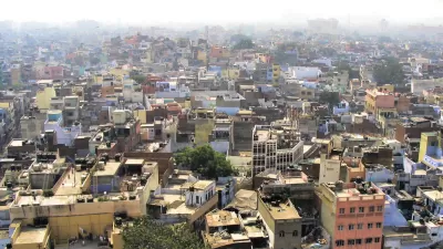
Wharton professor of real estate, Mariaflavia Harari writes in Knowlede @ Wharton about her research into the influence of the shape of a city on the economic success of residents and businesses. "My research question was what influence, if any, does a city’s shape have on the location choices of consumers and firms? Do consumers and firms benefit in terms of welfare or productivity from locating in cities with particular shapes?"
Harari’s research has made some interesting linkages between the shape of the city and average local wages and housing rents. More compact cities tend to have higher wages and rent, with circular cities being the most ideal for reducing commute times and improving efficiencies. However, since no city can be a perfect circle, Harari looks at the consequences of natural geography on a city.
…I’m not simply making a crude comparison between compact and non-compact cities in my analysis. I look at what happens when a given city becomes less compact as a result of hitting some topographic obstacle, like a mountain or a lake, as it expands in space. What I find is that when a city ends up with a worse geometry because of hitting some geographic constraints, its population growth slows down, and housing rents and local wages tend to decrease.
Harari writes that her research can have an impact, particularly in India, where growing cities are sprawling outward due to restrictions on building heights that limit opportunities for compact development that could lead to better efficiencies.
FULL STORY: What Urban Design Reveals about Economic Development


Planetizen Federal Action Tracker
A weekly monitor of how Trump’s orders and actions are impacting planners and planning in America.

San Francisco's School District Spent $105M To Build Affordable Housing for Teachers — And That's Just the Beginning
SFUSD joins a growing list of school districts using their land holdings to address housing affordability challenges faced by their own employees.

The Tiny, Adorable $7,000 Car Turning Japan Onto EVs
The single seat Mibot charges from a regular plug as quickly as an iPad, and is about half the price of an average EV.

Seattle's Plan for Adopting Driverless Cars
Equity, safety, accessibility and affordability are front of mind as the city prepares for robotaxis and other autonomous vehicles.

As Trump Phases Out FEMA, Is It Time to Flee the Floodplains?
With less federal funding available for disaster relief efforts, the need to relocate at-risk communities is more urgent than ever.

With Protected Lanes, 460% More People Commute by Bike
For those needing more ammo, more data proving what we already knew is here.
Urban Design for Planners 1: Software Tools
This six-course series explores essential urban design concepts using open source software and equips planners with the tools they need to participate fully in the urban design process.
Planning for Universal Design
Learn the tools for implementing Universal Design in planning regulations.
Smith Gee Studio
City of Charlotte
City of Camden Redevelopment Agency
City of Astoria
Transportation Research & Education Center (TREC) at Portland State University
US High Speed Rail Association
City of Camden Redevelopment Agency
Municipality of Princeton (NJ)