


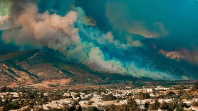
A summer of drought and devastating fires has demonstrated the dangers of allowing residential developments to sprawl ever farther into wild, natural environments.
According to on article by Laura Bliss, "as we make more and more homes along the very fringes of metropolitan areas, the more we come into contact with natural habitats."
The U.S.D.A. Forest Service has a term for these fringe places: "wildland-urban interface." According to Bliss, "Putting aside conservation concerns, higher numbers in the 'wildland/urban interface' (or the “WUI,” as the U.S.D.A Forest Service calls it) means higher numbers of homes vulnerable to wildfire."
"As of 2010, 99 million people, or about one-third of all people in the United States, lived in the WUI," reports Bliss. And the map of the WUI [pdf] is expanding.
For more on the development patterns that exacerbated the fire season in California, the Los Angeles Times also published an interview by Patt Morrison of Char Miller, professor of environmental analysis at Pomona College.
FULL STORY: Mapping America's Unprecedented Vulnerability to Wildfires

Home Insurers Are Fleeing California
Homeowners in the state are finding it increasingly difficult to secure insurance policies thanks to the growing risks of wildfire, drought, and other climate threats.
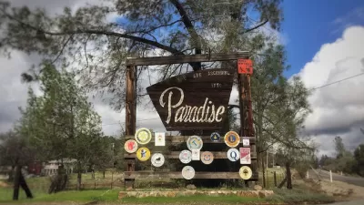
California's Fastest Growing City: Paradise
Paradise, California—devastated by the deadly Camp Fire of 2018—is attracting new and returning residents as the city rebuilds its housing stock.

6 Principles to Manage Wildfire Risk With Effective Housing Policy
The connection between housing policy and climate change is made clear by the increasing damage of wildfires in California.

Maui's Vacation Rental Debate Turns Ugly
Verbal attacks, misinformation campaigns and fistfights plague a high-stakes debate to convert thousands of vacation rentals into long-term housing.

Planetizen Federal Action Tracker
A weekly monitor of how Trump’s orders and actions are impacting planners and planning in America.

In Urban Planning, AI Prompting Could be the New Design Thinking
Creativity has long been key to great urban design. What if we see AI as our new creative partner?

King County Supportive Housing Program Offers Hope for Unhoused Residents
The county is taking a ‘Housing First’ approach that prioritizes getting people into housing, then offering wraparound supportive services.

Researchers Use AI to Get Clearer Picture of US Housing
Analysts are using artificial intelligence to supercharge their research by allowing them to comb through data faster. Though these AI tools can be error prone, they save time and housing researchers are optimistic about the future.

Making Shared Micromobility More Inclusive
Cities and shared mobility system operators can do more to include people with disabilities in planning and operations, per a new report.
Urban Design for Planners 1: Software Tools
This six-course series explores essential urban design concepts using open source software and equips planners with the tools they need to participate fully in the urban design process.
Planning for Universal Design
Learn the tools for implementing Universal Design in planning regulations.
planning NEXT
Appalachian Highlands Housing Partners
Mpact (founded as Rail~Volution)
City of Camden Redevelopment Agency
City of Astoria
City of Portland
City of Laramie