


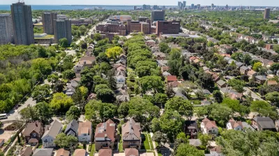
Mayor Rahm Emanuel announced an update of the city's 2013 transit oriented development ordinance. The new version of the ordinance would have a sweeping effect on the land uses around transit stations in Chicago.
"The office of Mayor Rahm Emanuel, who proposed and worked with City Council to pass a major TOD ordinance in 2013, unveiled a proposal for a reformed TOD ordinance," according to a post by Yonah Freemark for the Metropolitan Planning Council. For the record, the Metropolitan Planning Council "hails this proposed zoning ordinance as an important step forward in growing our city toward its transit system."
"An initial analysis of the ordinance conducted by MPC shows that the change would more than double the area of land benefiting from increased allowed density, compared with the 2013 ordinance, from 13 million sq. ft. of parcels to 31 million sq. ft. (this represents just a small portion of the city’s total developable area)," adds Freemark. The ordinance would also "increase by more than 10 times the area that would benefit from reduced parking requirements, from 86 million sq. ft. or parcels to 957 million."
The post includes a lot more info on the impacts the proposed ordinance could have enacted. For more information about the city's support of the new ordinance, which could be considered in September, see also a press release from the office of Mayor Rahm Emanuel about the proposed ordinance.
FULL STORY: City of Chicago unveils proposal for 2015 TOD ordinance


‘Biggest Little City’ Makes Room for Growth
The mayor of Reno has pushed for reforming housing regulations to support more affordable development.

Pittsburgh Mayor Proposes Zoning Changes to Curb Housing Shortage
The mayor’s plan includes legalizing ADUs in single-family neighborhoods, eliminating parking requirements, and adding new affordability requirements to buildings with over 20 units.
A Look at Milwaukee’s Proposed Zoning Reform
The proposed changes would permit more flexible housing development while limiting changes in historic neighborhoods and on smaller streets.

Montreal Mall to Become 6,000 Housing Units
Place Versailles will be transformed into a mixed-use complex over the next 25 years.

Planetizen Federal Action Tracker
A weekly monitor of how Trump’s orders and actions are impacting planners and planning in America.

DARTSpace Platform Streamlines Dallas TOD Application Process
The Dallas transit agency hopes a shorter permitting timeline will boost transit-oriented development around rail stations.

Study: 4% of Truckers Lack a Valid Commercial License
Over 56% of inspected trucks had other violations.

Chicago Judge Orders Thousands of Accessible Ped Signals
Only 3% of the city's crossing signals are currently accessible to blind pedestrians.

Philadelphia Swaps Car Lanes for Bikeways in Unanimous Vote
The project will transform one of the handful of streets responsible for 80% of the city’s major crashes.
Urban Design for Planners 1: Software Tools
This six-course series explores essential urban design concepts using open source software and equips planners with the tools they need to participate fully in the urban design process.
Planning for Universal Design
Learn the tools for implementing Universal Design in planning regulations.
City of Mt Shasta
City of Camden Redevelopment Agency
City of Astoria
Transportation Research & Education Center (TREC) at Portland State University
US High Speed Rail Association
City of Camden Redevelopment Agency
Municipality of Princeton (NJ)