


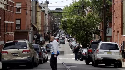
As city planners we are increasingly recording, measuring, and organizing city data—a practice known as urban science. Learn about resources across the globe helping to better understand our cities.


I recently traveled to Glasgow, Scotland with students and faculty from around the world learning about Cities and Citizens in the Digital Age. The sessions were wonderful, and I am sharing installments about a number of the key sessions of interest to the Planetizen community.
As city planners we are increasingly recording, measuring, and organizing city data—a practice known as urban science. Urban science is increasing in importance and universities across the globe are focusing on urban problems through urban science. Dr. Chris Pettit, a professor of Urban Science at the University of New South Wales, shared a range of labs and resources that are analyzing cities. Below is a list of resources offering insight and access into this emerging field. I encourage you to spend some time clicking through these websites—there is lots of planner eye candy, from gorgeous maps to fascinating city facts.
Australian Urban Research Infrastructure Network: AURIN is a national collaborative delivering e-research infrastructure to empower better decisions for Australia's urban settlements and their future development.
Beijing City Lab: The Beijing City Lab employs interdisciplinary methods to quantify urban dynamics, generating new insights for urban planning and governance and ultimately producing the science of cities required for sustainable urban development.
Center for Advanced Spatial Analysis: This center is a leading force in the science of cities, generating new knowledge and insights for use in city planning, policy, and design—drawing on the latest geospatial methods and ideas in computer-based visualization and modeling.
Center for Urban Science and Progress: The Center for Urban Science and Progress is a public-private research center that uses New York as its laboratory to help cities around the world become more productive, livable, equitable, and resilient.
Future Cities Laboratory: The Future Cities Laboratory focuses on sustainable urbanization on different scales in a global context.
The Programmable City Project: The Programmable City Project examines software-enabled technologies and services to augment and facilitate how we understand and plan cities, how we manage urban services and utilities, and how we live urban lives.
Senseable City Lab: The Senseable City Lab deploys sensors and hand-held electronics to study the build environment.
SustainCity: SustainCity addresses the modeling and computational issues of integrating modern mobility simulations with the latest micro-simulation land use models.
Urban Big Data Centre: The Urban Big Data Center is a resource promoting the use of innovative methods and complex urban data to solve global problems.
Urban Observatory: The Urban Observatory is an interactive app and website that allow people to compare and contrast cities from around the world. This of this as a "live museum with a data pulse."
Warwick Institute for the Science of Cities: WISC focuses on the means to gather city-scale data and the apparatus to transform this data into knowledge, capitalizing on emerging developments in big data and in interdisciplinary solutions to the world's urban challenges.


An Expanded Approach to the Analysis of Cities
Even with so much data in the world, cities are a slippery subject. What if an everyday part of life in cities—the "scenes" comprised by businesses, people, and practices of similarly distinct aesthetics—can help our understanding?

How Data-Driven Research Is Shaping Sustainable Urban Development
Explore how data-driven research is revolutionizing sustainable urban development, creating smarter, greener, and more resilient cities for the future.
Hoboken's Curbs Are Going Digital
Hoboken, New Jersey, is leveraging technology to up its curb management game with a digital streetscape map that will allow real-time demand monitoring.

Planetizen Federal Action Tracker
A weekly monitor of how Trump’s orders and actions are impacting planners and planning in America.

Maui's Vacation Rental Debate Turns Ugly
Verbal attacks, misinformation campaigns and fistfights plague a high-stakes debate to convert thousands of vacation rentals into long-term housing.

Restaurant Patios Were a Pandemic Win — Why Were They so Hard to Keep?
Social distancing requirements and changes in travel patterns prompted cities to pilot new uses for street and sidewalk space. Then it got complicated.

In California Battle of Housing vs. Environment, Housing Just Won
A new state law significantly limits the power of CEQA, an environmental review law that served as a powerful tool for blocking new development.

Boulder Eliminates Parking Minimums Citywide
Officials estimate the cost of building a single underground parking space at up to $100,000.

Orange County, Florida Adopts Largest US “Sprawl Repair” Code
The ‘Orange Code’ seeks to rectify decades of sprawl-inducing, car-oriented development.
Urban Design for Planners 1: Software Tools
This six-course series explores essential urban design concepts using open source software and equips planners with the tools they need to participate fully in the urban design process.
Planning for Universal Design
Learn the tools for implementing Universal Design in planning regulations.
Heyer Gruel & Associates PA
JM Goldson LLC
Custer County Colorado
City of Camden Redevelopment Agency
City of Astoria
Transportation Research & Education Center (TREC) at Portland State University
Jefferson Parish Government
Camden Redevelopment Agency
City of Claremont