


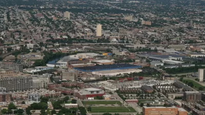
Once known as "Little Hell" for its copious industrial plants, Goose Island is a rare, relatively undeveloped investment opportunity. Centrally located, it may one day house swanky offices.

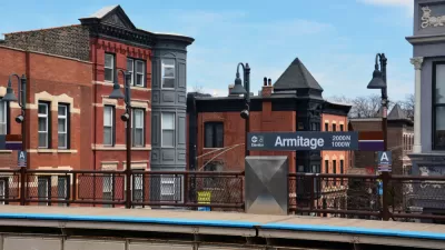
Known better as a beer, Chicago's Goose Island has finally caught the eye of developers and investors. Location is the main draw. Just north of downtown, Goose Island has easy access to vibrant neighborhoods like Lincoln Park and Wicker Park. To the east of Goose Island lies the erstwhile site of Cabrini-Green.
"Because it was designated by the city as a planned manufacturing district in 1991, the patch of land remains free of residential high-rises. The largely unchanged landscape, and its isolation, makes it one of the rarest urban planning opportunities in the country."
It is estimated that "40 percent of Goose Island is ripe for redevelopment within 20 years. Longtime tenants such as Big Bay Lumber, FedEx and Waste Management soon will be joined by a federally funded digital manufacturing lab and Amazon.com's first distribution facility in the city, among other new uses."
If Goose Island is destined to become a glorious office park, significant transportation investment will be needed. "A successful transformation will require infrastructure upgrades. Only one pedestrian bridge spans the river, and auto traffic frequently chokes the streets on and around the island."
FULL STORY: This neighborhood could be a model for urban planning by 2025

Chicago's Disappearing Multi-Unit Buildings
The city is seeing a rapid loss of its signature two-, three-, and four-flat residential buildings, which historically served as affordable housing for working-class families.
A 'Wild Mile' on the Chicago River Utilizes Floating Gardens
An effort is underway to reintroduce a natural habitats along a stretch of postindustrial Chicago River canal-scape. Floating garden modules are being used to attract species back to the area.
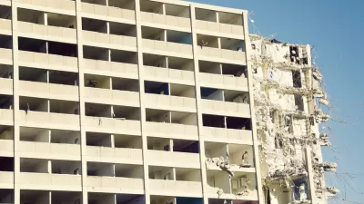
Large Mixed-Use Development the Latest Step in Cabrini-Green's Complete Redevelopment
The process of redeveloping the site of one of the country's most infamous public housing complexes, Cabrini-Green in Chicago, will soon take another substantial step into the future.

Maui's Vacation Rental Debate Turns Ugly
Verbal attacks, misinformation campaigns and fistfights plague a high-stakes debate to convert thousands of vacation rentals into long-term housing.

Planetizen Federal Action Tracker
A weekly monitor of how Trump’s orders and actions are impacting planners and planning in America.

Chicago’s Ghost Rails
Just beneath the surface of the modern city lie the remnants of its expansive early 20th-century streetcar system.

Bend, Oregon Zoning Reforms Prioritize Small-Scale Housing
The city altered its zoning code to allow multi-family housing and eliminated parking mandates citywide.

Amtrak Cutting Jobs, Funding to High-Speed Rail
The agency plans to cut 10 percent of its workforce and has confirmed it will not fund new high-speed rail projects.

LA Denies Basic Services to Unhoused Residents
The city has repeatedly failed to respond to requests for trash pickup at encampment sites, and eliminated a program that provided mobile showers and toilets.
Urban Design for Planners 1: Software Tools
This six-course series explores essential urban design concepts using open source software and equips planners with the tools they need to participate fully in the urban design process.
Planning for Universal Design
Learn the tools for implementing Universal Design in planning regulations.
planning NEXT
Appalachian Highlands Housing Partners
Mpact (founded as Rail~Volution)
City of Camden Redevelopment Agency
City of Astoria
City of Portland
City of Laramie