


Many places are statistically diverse, but their inhabits can be worlds apart. A local perspective (and finer data) is needed to fully appreciate how different races and classes inhabit a neighborhood.
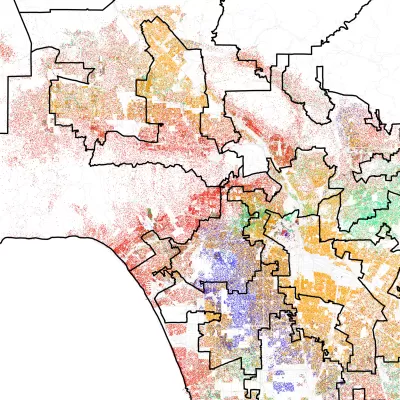
While the 98118 zip code near Seattle gained some fame in 2010 for its statistical diversity, University of Washington researchers Ryan Gabriel and Tim Thomas weren't so sure. They decided to take a closer look. Said Gabriel, "'It's a highly-diverse city in some ways, but as you kind of walk the city, you experience a real sense of separation between racial groups and class levels as well.'"
There can be cultural and economic gulfs between communities only minutes apart. From the article: "In Columbia City, for example, the researchers found the west side of the tract had lots of immigrant markets and fast food restaurants. On the predominantly white side of the tract near the bay were five-star restaurants serving $60 entrees."
In that example, even a physical barrier separated white from black, rich from poor. "A steep north-south ridge that can't be crossed by foot divides the tract. More than 78 percent of black residents life on the west side of the ridge, where most homes are run down and few new homes exist [...]"
The researchers found similar results in cities across the United States. The racial dot map, a version of which appears in the article, is an invaluable tool to appreciate finer degrees of segregation. The map uses 2010 census data and includes Hawaii and Alaska.
FULL STORY: When “diverse” neighborhoods are more segregated than they appear


How Cities Can Avoid Perpetuating Segregation
Residents of big cities, known as the ‘melting pots’ of America, have fewer interactions with people outside their socioeconomic group than those in smaller communities, according to new research.

What We Really Mean When We Say Gentrification
The focus on gentrifying communities has, in many cases, eclipsed the similar problems facing more stagnant neighborhoods.
What Trump Gets Wrong About America’s Suburbs
The Trump administration’s talk about protecting the suburbs is based on misrepresentations of who really lives in suburbs and what these communities need.

Planetizen Federal Action Tracker
A weekly monitor of how Trump’s orders and actions are impacting planners and planning in America.

Congressman Proposes Bill to Rename DC Metro “Trump Train”
The Make Autorail Great Again Act would withhold federal funding to the system until the Washington Metropolitan Area Transit Authority (WMATA), rebrands as the Washington Metropolitan Authority for Greater Access (WMAGA).

The Simple Legislative Tool Transforming Vacant Downtowns
In California, Michigan and Georgia, an easy win is bringing dollars — and delight — back to city centers.

The States Losing Rural Delivery Rooms at an Alarming Pace
In some states, as few as 9% of rural hospitals still deliver babies. As a result, rising pre-term births, no adequate pre-term care and "harrowing" close calls are a growing reality.

The Small South Asian Republic Going all in on EVs
Thanks to one simple policy change less than five years ago, 65% of new cars in this Himalayan country are now electric.

DC Backpedals on Bike Lane Protection, Swaps Barriers for Paint
Citing aesthetic concerns, the city is removing the concrete barriers and flexposts that once separated Arizona Avenue cyclists from motor vehicles.
Urban Design for Planners 1: Software Tools
This six-course series explores essential urban design concepts using open source software and equips planners with the tools they need to participate fully in the urban design process.
Planning for Universal Design
Learn the tools for implementing Universal Design in planning regulations.
Smith Gee Studio
City of Charlotte
City of Camden Redevelopment Agency
City of Astoria
Transportation Research & Education Center (TREC) at Portland State University
US High Speed Rail Association
City of Camden Redevelopment Agency
Municipality of Princeton (NJ)