


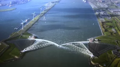
A radical approach to flood control in the Netherlands will expand the flood plain of the River Waal while also creating new neighborhoods where people can live and work.
Letty Reimerink explains the unusual response by the city of Nijmegan in the Netherlands to a 1995 flood event along the banks of the River Waal. Although the flood control project underway in Nijmegan is unique, as Reimerink explains, it's also "filled with ideas that river cities anywhere can learn from."
The Nijmegan model is exemplary for two reasons:
- "First, Nijmegen is not simply raising or strengthening its dikes, which might seem like the obvious solution. Instead, it is moving some dikes back from the river, essentially creating a much wider floodplain."
- The second reason is the additional benefits to land use and development that will be created by the project. The project will create to new neighborhoods for development and four new bridges to connect this " new urban heart" in the middle of the river.
The project in Nijmegan is one example of a national program called Room for the River. According to Reimerink, "The project in Nijmegen — Room for the River Waal — is the biggest and most awe-inspiring of the national program." The article details more of the specifics of the Nijmegan as well as the political support that the project required for fruition. The article concludes with a discussion of the challenges still facing Nijmegen if it wants to take full advantage of its new relationship with the river.
FULL STORY: A Dutch city makes room for its river — and a new identity


Subways Are Becoming Flood Zones
While cities race to protect their subway infrastructure from more intense flooding, some experts argue that more investment is needed in more resilient street-level infrastructure.
The Dutch: Ready to Export Their Flood Control Expertise
For those who want it, the Netherlands is willing to share the fruits of its centuries-long relationship with the unruly seas. In Rotterdam, lots of local urban solutions are also on display.
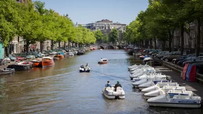
Roboboats, err...Roboats May Soon Navigate Amsterdam's Canals
Small, self-navigating boats may soon ferry around passengers and cargo on Amsterdam's famed canals, with a prototype scheduled to hit the water next year.

Maui's Vacation Rental Debate Turns Ugly
Verbal attacks, misinformation campaigns and fistfights plague a high-stakes debate to convert thousands of vacation rentals into long-term housing.

Planetizen Federal Action Tracker
A weekly monitor of how Trump’s orders and actions are impacting planners and planning in America.

San Francisco Suspends Traffic Calming Amidst Record Deaths
Citing “a challenging fiscal landscape,” the city will cease the program on the heels of 42 traffic deaths, including 24 pedestrians.

Defunct Pittsburgh Power Plant to Become Residential Tower
A decommissioned steam heat plant will be redeveloped into almost 100 affordable housing units.

Trump Prompts Restructuring of Transportation Research Board in “Unprecedented Overreach”
The TRB has eliminated more than half of its committees including those focused on climate, equity, and cities.

Amtrak Rolls Out New Orleans to Alabama “Mardi Gras” Train
The new service will operate morning and evening departures between Mobile and New Orleans.
Urban Design for Planners 1: Software Tools
This six-course series explores essential urban design concepts using open source software and equips planners with the tools they need to participate fully in the urban design process.
Planning for Universal Design
Learn the tools for implementing Universal Design in planning regulations.
Heyer Gruel & Associates PA
JM Goldson LLC
Custer County Colorado
City of Camden Redevelopment Agency
City of Astoria
Transportation Research & Education Center (TREC) at Portland State University
Jefferson Parish Government
Camden Redevelopment Agency
City of Claremont