


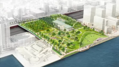
Project planners estimate that a $200 million investment in an 11-acre cap park over I-95 that will reconnect the city with the Delaware River could return $1 billion in private investment.
Kellie Patrick Gates relays information shared during a meeting between the Central Delaware Advocacy Group and Delaware River Waterfront Corporation about the progress by project designer Hargreaves Associates on a conceptual plan for a new Penn’s Landing. The project includes 11-acre cap park, which would stretch from Front Street to the Delaware River by capping I-95 and Delaware Avenue.
The current cost estimate for the plan is $205 million in public investment (and the plan is expected to be difficult to fund). But according to Gates, [the] idea is that investment would spur the private parts of the development – the residences, restaurants, shops and the like – to the tune of $800 million or even $1 billion.”
Some details about how the park's conceptual designs are taking shape:
- The park “would be engineered so that trees can be planted on what feels like ground level, and it would end at the waterfront in a large public space, framed by an amphitheater.”
- “Low-rise residential development with mixed uses on the ground floor would start along the middle of the boat basin, and then fill in with mid-rise near the Hyatt and on the opposite end.”
Gates’s article also makes the point, by paraphrasing Delaware River Waterfront Corporation Chairman Matt Ruben, that the Penn’s Landing plan will have a higher economic benefit than typical highway projects because freeway widenings don’t spur economic development in surrounding land uses.
FULL STORY: "Conceptual framework" for new Penn's Landing nearing completion

Revealed: $2.2 Billion Redevelopment Plan for Philadelphia's Waterfront
The city of Philadelphia has a new, highly anticipated plan for a valuable site on the Delaware River waterfront.
A Development Bonanza in Philadelphia
The Philadelphia 76ers are one of the real estate interests with designs on remaking the Penn's Landing site on the Delaware River in Philadelphia. But the team's vision for the waterfront reaches far beyond a single parcel.
Iconic Remnants of Failed Tram on the Philly Waterfront to Be Demolished
It's the end of an era that never was.

Maui's Vacation Rental Debate Turns Ugly
Verbal attacks, misinformation campaigns and fistfights plague a high-stakes debate to convert thousands of vacation rentals into long-term housing.

Planetizen Federal Action Tracker
A weekly monitor of how Trump’s orders and actions are impacting planners and planning in America.

San Francisco Suspends Traffic Calming Amidst Record Deaths
Citing “a challenging fiscal landscape,” the city will cease the program on the heels of 42 traffic deaths, including 24 pedestrians.

Adaptive Reuse Will Create Housing in a Suburban Texas Strip Mall
A developer is reimagining a strip mall property as a mixed-use complex with housing and retail.

Study: Anti-Homelessness Laws Don’t Work
Research shows that punitive measures that criminalized unhoused people don’t help reduce homelessness.

In U.S., Urban Gondolas Face Uphill Battle
Cities in Latin America and Europe have embraced aerial transitways — AKA gondolas — as sustainable, convenient urban transport, especially in tricky geographies. American cities have yet to catch up.
Urban Design for Planners 1: Software Tools
This six-course series explores essential urban design concepts using open source software and equips planners with the tools they need to participate fully in the urban design process.
Planning for Universal Design
Learn the tools for implementing Universal Design in planning regulations.
Heyer Gruel & Associates PA
JM Goldson LLC
Custer County Colorado
City of Camden Redevelopment Agency
City of Astoria
Transportation Research & Education Center (TREC) at Portland State University
Jefferson Parish Government
Camden Redevelopment Agency
City of Claremont