


Local officials agree that a light rail system from Miami to Miami Beach would work, and they have embarked on a partnership to win the funding to commence a study of a potential $532 million route.
Political leaders are backing early plans to build a passenger light-rail system from Government Center in downtown Miami to the Convention Center in Miami Beach, reports Alfonso Chardy for the Miami Herald. According to an estimate this week by project planners, a route above the MacArthur Causeway route would cost an estimated $532 million to build and $22 million a year to operate and maintain.
At a hearing on the project this week, Mayors Carlos Gimenez of Miami-Dade, Tomás Regalado of Miami and Philip Levine of Miami Beach took the very first steps in exploring the project: they agreed “to form a partnership to find the $3 million they need to finance a project development study,” reports Chardy. “[The] $3 million would include $250,000 each from Miami-Dade, Miami and Miami Beach, along with $750,000 from the Florida Department of Transportation (FDOT) and $1.5 million from the U.S. Department of Transportation (USDOT).”
Project planners provided initial planning reports for the project in a January hearing, with a route over the MacArther Causeway being the early frontrunner based on the reaction of mayors Giminez and Regalado.
FULL STORY: Light rail to Miami Beach may cost $532 million


Miami Beach Could Permanently Pedestrianize Ocean Drive
The city banned vehicle traffic from the popular street during the pandemic. Now, transportation planners hope to make the change permanent as part of a new plan to prioritize pedestrians and improve transportation in the Entertainment District.

Kayaking, Canvassing, and Cooking Classes: Cities Experiment With Climate Outreach
As cities across the U.S. commit to ambitious climate actions, they're seeking effective ways to engage with local communities.
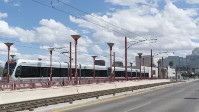
Phoenix City Council Shifts Voter-Approved Light Rail Project Funding to Roads
Locally generated sales tax revenue will no longer fund a planned light rail extension in west Phoenix.

Maui's Vacation Rental Debate Turns Ugly
Verbal attacks, misinformation campaigns and fistfights plague a high-stakes debate to convert thousands of vacation rentals into long-term housing.

Planetizen Federal Action Tracker
A weekly monitor of how Trump’s orders and actions are impacting planners and planning in America.

In Urban Planning, AI Prompting Could be the New Design Thinking
Creativity has long been key to great urban design. What if we see AI as our new creative partner?

Portland Raises Parking Fees to Pay for Street Maintenance
The city is struggling to bridge a massive budget gap at the Bureau of Transportation, which largely depleted its reserves during the Civd-19 pandemic.

Spokane Mayor Introduces Housing Reforms Package
Mayor Lisa Brown’s proposals include deferring or waiving some development fees to encourage more affordable housing development.

Houston Mayor Kills Another Bike Lane
The mayor rejected a proposed bike lane in the Montrose district in keeping with his pledge to maintain car lanes.
Urban Design for Planners 1: Software Tools
This six-course series explores essential urban design concepts using open source software and equips planners with the tools they need to participate fully in the urban design process.
Planning for Universal Design
Learn the tools for implementing Universal Design in planning regulations.
Gallatin County Department of Planning & Community Development
Heyer Gruel & Associates PA
JM Goldson LLC
City of Camden Redevelopment Agency
City of Astoria
Transportation Research & Education Center (TREC) at Portland State University
Jefferson Parish Government
Camden Redevelopment Agency
City of Claremont