


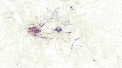
The three geographers behind the Floating Sheep blog have created a world map of Internet references to zombies.

Mark Graham, Taylor Shelton, and Matthew Zook queried Google’s geo-tagged information for zombie-related keywords, including references to Halloween events, Halloween costumes, and purported zombie sightings.
New York, Los Angeles, San Francisco, and London have the largest number of references. Non-English speaking locales may have slipped through the cracks, since the researchers conducted the search in English. Graham, Shelton, and Zook went on to map preferred zombie-killing weapons by regions.
“This whole exercise is meant to make a broader point about the utility and limitations of the geoweb,” Emily Badger writes. Some of the information uncovered by the geographers seems to hold real meaning. But their project also made clear the unreliability of Internet evidence. “[Y]ou probably wouldn’t want to rely on these maps alone to prepare for the zombie apocalypse,” Badger concludes.
FULL STORY: Where We're Obsessed With Zombies

Friday Eye Candy: Maps Reveal Differences in How Locals and Tourists See the City
The cities that visitors see will always be different than the city that locals see. A new mapping project reveals the distinctions between the local perspective and the tourist perspective for 136 cities around the globe.

Interactive Map Reveals America's “Shade Deserts”
Launched by UCLA and American Forests to combat heat-related deaths, the tool maps the shade infrastructure for over 360 U.S. cities.

Maps: How Much of Your City is Parking?
The percentage of land dedicated to parking in the central districts of major U.S. cities ranges from 4 percent to as much as 42 percent.

Maui's Vacation Rental Debate Turns Ugly
Verbal attacks, misinformation campaigns and fistfights plague a high-stakes debate to convert thousands of vacation rentals into long-term housing.

Planetizen Federal Action Tracker
A weekly monitor of how Trump’s orders and actions are impacting planners and planning in America.

In Urban Planning, AI Prompting Could be the New Design Thinking
Creativity has long been key to great urban design. What if we see AI as our new creative partner?

Portland Raises Parking Fees to Pay for Street Maintenance
The city is struggling to bridge a massive budget gap at the Bureau of Transportation, which largely depleted its reserves during the Civd-19 pandemic.

Spokane Mayor Introduces Housing Reforms Package
Mayor Lisa Brown’s proposals include deferring or waiving some development fees to encourage more affordable housing development.

Houston Mayor Kills Another Bike Lane
The mayor rejected a proposed bike lane in the Montrose district in keeping with his pledge to maintain car lanes.
Urban Design for Planners 1: Software Tools
This six-course series explores essential urban design concepts using open source software and equips planners with the tools they need to participate fully in the urban design process.
Planning for Universal Design
Learn the tools for implementing Universal Design in planning regulations.
Gallatin County Department of Planning & Community Development
Heyer Gruel & Associates PA
JM Goldson LLC
City of Camden Redevelopment Agency
City of Astoria
Transportation Research & Education Center (TREC) at Portland State University
Jefferson Parish Government
Camden Redevelopment Agency
City of Claremont