


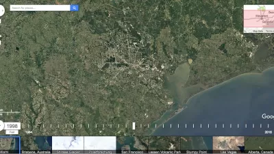
With Earth Engine, Google has compiled decades of images taken by Earth-observing satellites. The tool is meant for "scientists, independent researchers, and nations...to detect changes, map trends and quantify differences on the Earth's surface."
"Today, Google put out the Earth Engine, a fascinating tool that showcases a scrollable, zoomable time-lapse of the entire planet as seen by Landsat over the decades," writes Colin Schultz. According to Rebecca Moore, Engineering Manager with Google Earth Engine & Earth Outreach, the images paint "the most comprehensive picture of our changing planet ever made available to the public."
"The Landsat photos only go back to 1984," says Schultz, "but they show the dramatic ways in which the planet has changed in such a brief period of time. To help you get started, Google pulled out some highlights to look at, such as the drying of the Aral Sea or the deforestation of the Amazon. But the tool does show the whole planet (just the land, not the oceans), and there are many more cool things to be seen."
FULL STORY: 28-Year Satellite Time-Lapse Shows Exactly What We’re Doing to Our Planet

Friday Eye Candy: A 30-Year Timelapse Reveals Humanity's Expanding Footprint
The Google Timelapse feature has been updated. The only thing that stays the same is that everything changes.

Why a Failed ‘Smart City’ Is Still Relevant
A Google-backed proposal to turn an underused section of Toronto waterfront into a tech hub holds relevant lessons about privacy and data.
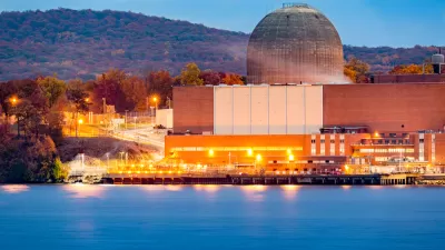
Google Inks Nuclear Power Deal
Tech giants are seeking out renewable energy to fuel power-hungry data centers and AI applications.

Maui's Vacation Rental Debate Turns Ugly
Verbal attacks, misinformation campaigns and fistfights plague a high-stakes debate to convert thousands of vacation rentals into long-term housing.

Planetizen Federal Action Tracker
A weekly monitor of how Trump’s orders and actions are impacting planners and planning in America.

San Francisco Suspends Traffic Calming Amidst Record Deaths
Citing “a challenging fiscal landscape,” the city will cease the program on the heels of 42 traffic deaths, including 24 pedestrians.

Defunct Pittsburgh Power Plant to Become Residential Tower
A decommissioned steam heat plant will be redeveloped into almost 100 affordable housing units.

Trump Prompts Restructuring of Transportation Research Board in “Unprecedented Overreach”
The TRB has eliminated more than half of its committees including those focused on climate, equity, and cities.

Amtrak Rolls Out New Orleans to Alabama “Mardi Gras” Train
The new service will operate morning and evening departures between Mobile and New Orleans.
Urban Design for Planners 1: Software Tools
This six-course series explores essential urban design concepts using open source software and equips planners with the tools they need to participate fully in the urban design process.
Planning for Universal Design
Learn the tools for implementing Universal Design in planning regulations.
Heyer Gruel & Associates PA
JM Goldson LLC
Custer County Colorado
City of Camden Redevelopment Agency
City of Astoria
Transportation Research & Education Center (TREC) at Portland State University
Jefferson Parish Government
Camden Redevelopment Agency
City of Claremont