


As the virtual and physical worlds become more intertwined, the role of the traditional architect and the information architect become more closely aligned. Emily Badger explores the ways that each discipline can help the other design public spaces.
"We are wrong to treat them as two totally separate things," says John Tolva, the Chief Technology Officer for the city of Chicago, about information architects and traditional architects. "I see a lot of people in information disciplines trying to resolve problems that architects of the built world have already solved."
"Traditional architects (we’ll go with 'traditional' here instead of 'real') have spent centuries figuring out how to create successful public spaces," adds Badger. "But information architects still regularly struggle with this question online."
Facebook is one example of a virtual space that simulates a real world equivalent, and to which real world lessons for creating vibrant public spaces could apply. "Facebook’s approach to digital space, to borrow from Tolva’s blog, is 'essentially suburbia: a gated network of affinity that disallows chance encounter and serendipity.'"
"Facebook looks different when you think about it through this lens," says Badger. "And the same becomes true of our cities – and buildings and parks – when we think about them as platforms for information. Perhaps, then, it's time for building designers and information designers to get to know each other better, maybe even blend the edges of their professions."
FULL STORY: What an Urban Planner Should Look Like in the Internet Age


Survey: US Public Spaces Not Meeting Community Needs
A lack of funding prevents many U.S. parks and public spaces from playing a more significant role in helping residents meet daily needs.
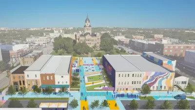
North Texas Town Launches Downtown Revitalization Plan
The Design Downtown Denton plan takes aim at improving walkability and highlighting the city’s historic assets.

Can Urban Design Truly Impact Loneliness?
Some theorists want to design cities to reduce loneliness and isolation. Others want to accommodate them.

Maui's Vacation Rental Debate Turns Ugly
Verbal attacks, misinformation campaigns and fistfights plague a high-stakes debate to convert thousands of vacation rentals into long-term housing.

Planetizen Federal Action Tracker
A weekly monitor of how Trump’s orders and actions are impacting planners and planning in America.

In Urban Planning, AI Prompting Could be the New Design Thinking
Creativity has long been key to great urban design. What if we see AI as our new creative partner?

Cal Fire Chatbot Fails to Answer Basic Questions
An AI chatbot designed to provide information about wildfires can’t answer questions about evacuation orders, among other problems.

What Happens if Trump Kills Section 8?
The Trump admin aims to slash federal rental aid by nearly half and shift distribution to states. Experts warn this could spike homelessness and destabilize communities nationwide.

Sean Duffy Targets Rainbow Crosswalks in Road Safety Efforts
Despite evidence that colorful crosswalks actually improve intersection safety — and the lack of almost any crosswalks at all on the nation’s most dangerous arterial roads — U.S. Transportation Secretary Duffy is calling on states to remove them.
Urban Design for Planners 1: Software Tools
This six-course series explores essential urban design concepts using open source software and equips planners with the tools they need to participate fully in the urban design process.
Planning for Universal Design
Learn the tools for implementing Universal Design in planning regulations.
Appalachian Highlands Housing Partners
Gallatin County Department of Planning & Community Development
Heyer Gruel & Associates PA
Mpact (founded as Rail~Volution)
City of Camden Redevelopment Agency
City of Astoria
City of Portland
City of Laramie