


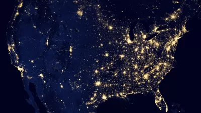
This week, scientists unveiled unprecedented images of the Earth at night, as captured by a new NASA and National Oceanic and Atmospheric Administration (NOAA) satellite.
Assembled from data acquired by the NASA-NOAA Suomi National Polar-orbiting Partnership (NPP) satellite in April and October 2012, the stunning images unveiled at this week's American Geophysical Union meeting in San Francisco, show "the glow of natural and human-built phenomena across the planet in greater detail than ever before."
According to NASA, the satellite, which was launched last year, is equipped with a new sensor (VIIRS) that "is sensitive enough to detect the nocturnal glow produced by Earth's atmosphere and the light from a single ship in the sea."
"'For all the reasons that we need to see Earth during the day, we also need to see Earth at night,' said Steve Miller, a researcher at NOAA's Colorado State University Cooperative Institute for Research in the Atmosphere. 'The night is nowhere as dark as we might think,' Miller said. And with the VIIRS day-night band helping scientists to tease out information from human and natural sources of nighttime light, 'we don't have to be in the dark anymore, either.'"
For a critical take on what the images reveal about politics, the environment and borders, see Olga Khazan's piece in The Washington Post.
FULL STORY: NASA-NOAA Satellite Reveals New Views of Earth at Night

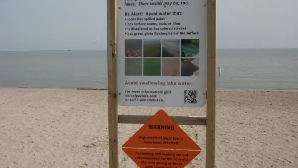
NOAA Great Lakes Lab Loses Key Funding
Cuts at a lab that monitors water quality in the Great Lakes region could harm efforts to prevent dangerous algal blooms.
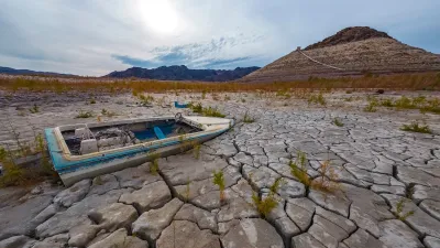
NOAA: Southwest ‘Megadrought’ to Persist
Roughly 40 percent of the 48 lower U.S. states are currently in some state of ‘abnormally dry conditions.’

How Effective Street Lighting Improves Women’s Mobility
A lack of effective lighting in streets, parks, and transit stations limits the places where many women and other vulnerable groups feel safe traveling at night.

Planetizen Federal Action Tracker
A weekly monitor of how Trump’s orders and actions are impacting planners and planning in America.

Map: Where Senate Republicans Want to Sell Your Public Lands
For public land advocates, the Senate Republicans’ proposal to sell millions of acres of public land in the West is “the biggest fight of their careers.”

Restaurant Patios Were a Pandemic Win — Why Were They so Hard to Keep?
Social distancing requirements and changes in travel patterns prompted cities to pilot new uses for street and sidewalk space. Then it got complicated.

Maui's Vacation Rental Debate Turns Ugly
Verbal attacks, misinformation campaigns and fistfights plague a high-stakes debate to convert thousands of vacation rentals into long-term housing.

San Francisco Suspends Traffic Calming Amidst Record Deaths
Citing “a challenging fiscal landscape,” the city will cease the program on the heels of 42 traffic deaths, including 24 pedestrians.

California Homeless Arrests, Citations Spike After Ruling
An investigation reveals that anti-homeless actions increased up to 500% after Grants Pass v. Johnson — even in cities claiming no policy change.
Urban Design for Planners 1: Software Tools
This six-course series explores essential urban design concepts using open source software and equips planners with the tools they need to participate fully in the urban design process.
Planning for Universal Design
Learn the tools for implementing Universal Design in planning regulations.
Heyer Gruel & Associates PA
JM Goldson LLC
Custer County Colorado
City of Camden Redevelopment Agency
City of Astoria
Transportation Research & Education Center (TREC) at Portland State University
Camden Redevelopment Agency
City of Claremont
Municipality of Princeton (NJ)