


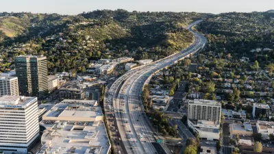
After a weekend in which Los Angeles successfully navigated the closure of one of its most clogged freeways once again, we look back at the disastrous effect that freeway construction had on L.A.'s communities during the middle of the last century.
Carmageddon II went off without a hitch this past weekend, as Angelenos easily adjusted their schedules and transportation plans to avoid the closure of a crucial stretch of the San Diego Freeway and celebrated their local communities. However, for three decades in the middle of the last century, and with repercussions ever since, the process by which the Santa Monica Freeway was planned and constructed tore apart L.A.'s neighborhoods. Nathan Masters traces the planning and construction of the I-10 Freeway, "an indelible marker across the Los
Angeles landscape, a mini-equator that delineates boundaries between
cultural and historical hemispheres of the city," segregating the affluent north of the city from the disadvantaged south.
Constructed as part of L.A.'s second generation of freeways, the I-10 was built as "part of a broader statewide and national effort."
"With this backing," says Masters, "came bolder plans and a tendency to subordinate local
concerns to the needs of the larger region. Mapping their proposed
routes, planners drew lines straight through established residential
communities. Houses and local businesses along the route were no more an
obstacle than existing surface streets or water mains; the state would
purchase whatever property it needed, relocate residents, and
reconfigure the neighborhoods around the new freeway."
FULL STORY: Creating the Santa Monica Freeway, Building Walls Across Communities

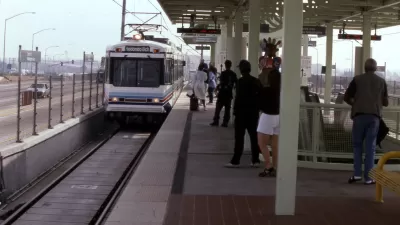
Considering the Legacy of the Metro Green Line after 25 Years of Service
25 years of the Metro C (Green) Line means reckoning with a history of destruction and displacement while looking forward to upcoming improvements.
Five Years After $1 Billion Freeway Expansion, Traffic Only Gets Worse
The lesson of the I-405 widening project that birthed meme-worthy events like "Carmageddon": widening a freeway won't reduce congestion for long, if ever.
The Real Jurassic Park: Why a Highway Widening Project Hasn't Been Entirely Bad for L.A.
The highway widening project that's slowed traffic along the already slothful 405 freeway for the past four years, and brought us the revelatory event known as "Carmageddon", hasn't been all bad news. It offers a glimpse of the city's oldest rocks.

Maui's Vacation Rental Debate Turns Ugly
Verbal attacks, misinformation campaigns and fistfights plague a high-stakes debate to convert thousands of vacation rentals into long-term housing.

Planetizen Federal Action Tracker
A weekly monitor of how Trump’s orders and actions are impacting planners and planning in America.

Chicago’s Ghost Rails
Just beneath the surface of the modern city lie the remnants of its expansive early 20th-century streetcar system.

Bend, Oregon Zoning Reforms Prioritize Small-Scale Housing
The city altered its zoning code to allow multi-family housing and eliminated parking mandates citywide.

Amtrak Cutting Jobs, Funding to High-Speed Rail
The agency plans to cut 10 percent of its workforce and has confirmed it will not fund new high-speed rail projects.

LA Denies Basic Services to Unhoused Residents
The city has repeatedly failed to respond to requests for trash pickup at encampment sites, and eliminated a program that provided mobile showers and toilets.
Urban Design for Planners 1: Software Tools
This six-course series explores essential urban design concepts using open source software and equips planners with the tools they need to participate fully in the urban design process.
Planning for Universal Design
Learn the tools for implementing Universal Design in planning regulations.
planning NEXT
Appalachian Highlands Housing Partners
Mpact (founded as Rail~Volution)
City of Camden Redevelopment Agency
City of Astoria
City of Portland
City of Laramie