


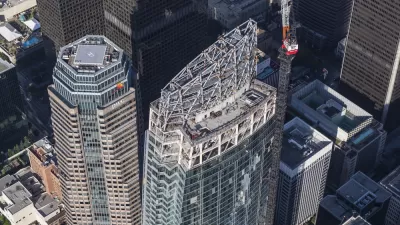
Los Angeles Fire Code rules requiring helicopter landing zones on the city's high rises has led to one of the most bland skylines in America. As the city updates its fire code, a new working group is seeking to unleash the creativity of designers.
Earlier this year, we pointed to an article that explained why the Los Angeles skyline suffers from flat top syndrome. Now comes promising news that the Fire Department may be open to relaxing the requirements for rooftop helicopter landing space, in place since 1974, if enough building safety innovations can be identified by a working group, reports James Brasuell.
"At the request of Fire Chief Brian Cummings, Deputy Fire Chief Mark
Stormes has assembled officials from the Fire Department and the
Department of Building and Safety, local architects, and public safety
consultants to report on possible changes to the regulations," notes Brasuell. "Chief
Stormes described the group as a 'bunch of bright people with good ideas
in the field of design and structural engineering,' who will hopefully 'do away with the perception that we aren't willing to listen.'"
Although there's reason to believe the helicopter requirement is likely to stay intact in some form, there's optimism that a compromise can be reached to allow for more variation in rooftop articulation.
FULL STORY: Change on the Horizon

Flat Tops No Longer Required for Los Angeles Skyscrapers
Emily Alpert Reyes reports that Los Angeles has overturned a long-standing requirement for its skyscrapers to have flat roofs to accommodate the fire department's helicopters in the event of an emergency.
New Tallest Building West of the Mississippi Now Open
Friday was the first day the public could walk into Los Angeles' new iconic skyscraper. The Wilshire Grand is noteworthy for more than just its height.

LA Denies Basic Services to Unhoused Residents
The city has repeatedly failed to respond to requests for trash pickup at encampment sites, and eliminated a program that provided mobile showers and toilets.

Planetizen Federal Action Tracker
A weekly monitor of how Trump’s orders and actions are impacting planners and planning in America.

Chicago’s Ghost Rails
Just beneath the surface of the modern city lie the remnants of its expansive early 20th-century streetcar system.

San Antonio and Austin are Fusing Into one Massive Megaregion
The region spanning the two central Texas cities is growing fast, posing challenges for local infrastructure and water supplies.

Since Zion's Shuttles Went Electric “The Smog is Gone”
Visitors to Zion National Park can enjoy the canyon via the nation’s first fully electric park shuttle system.

Trump Distributing DOT Safety Funds at 1/10 Rate of Biden
Funds for Safe Streets and other transportation safety and equity programs are being held up by administrative reviews and conflicts with the Trump administration’s priorities.

German Cities Subsidize Taxis for Women Amid Wave of Violence
Free or low-cost taxi rides can help women navigate cities more safely, but critics say the programs don't address the root causes of violence against women.
Urban Design for Planners 1: Software Tools
This six-course series explores essential urban design concepts using open source software and equips planners with the tools they need to participate fully in the urban design process.
Planning for Universal Design
Learn the tools for implementing Universal Design in planning regulations.
planning NEXT
Appalachian Highlands Housing Partners
Mpact (founded as Rail~Volution)
City of Camden Redevelopment Agency
City of Astoria
City of Portland
City of Laramie