


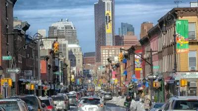
In the aftermath of Hurricane Irene, Fast Company's Boyd Cohen writes how New York City's preparedness for Hurricane's should include enhancing infrastructure in things like the Internet and transit.
Stories of people without wifi and power that flooded Starbucks and Dunkin Donuts calls for a more expansive internet infrastructure, Cohen argues.
"What if GPS, Wi-Fi and mobile technology were completely ubiquitous in all parts of the city, including the poorest parts? City administrators could enter in the GPS coordinates of everything from at-risk neighborhoods and rivers to the location of the nearest safe shelters, the nearest transit option to escape the city to higher ground and the nearest available potable water sources and much more. Assuming all citizens had access to GPS-enabled devices, citizens in distress could indicate with a text to 911 that they were in trouble and the GPS coordinates would be instantaneously available to first responders. With some kind of opt-in system, residents could even receive real-time text updates tied to their GPS coordinates."
"Smart Transit" hasn't arrived completely, Cohen says, but it is already on it's on the right track.
"The Helsinki Journey Planner, for example, has an open data protocol to enable city websites and third party developers to tap into the transit system and provide real-time data on transit schedules. "
FULL STORY: If New York City Becomes The "Smartest" City In The World, How Will It Prepare For Future Hurricanes?

Thinking About Infrastructure and Housing, Part 2
Is inadequate infrastructure a reason to keep new housing out of cities?
How Planners Can Help Cities Thrive
For planners, the key to moving a city’s vision for development forward is to value public as well as private investment in projects, according to urban planner and author Howard M. Blackson III.
The Unseen Space: Signal Space
With a growing demand for wireless internet, mobile communication networks may encroach on public space, writes Michael Chen, adjunct assistant professor at the Pratt Institute School of Architecture.

Maui's Vacation Rental Debate Turns Ugly
Verbal attacks, misinformation campaigns and fistfights plague a high-stakes debate to convert thousands of vacation rentals into long-term housing.

Planetizen Federal Action Tracker
A weekly monitor of how Trump’s orders and actions are impacting planners and planning in America.

In Urban Planning, AI Prompting Could be the New Design Thinking
Creativity has long been key to great urban design. What if we see AI as our new creative partner?

King County Supportive Housing Program Offers Hope for Unhoused Residents
The county is taking a ‘Housing First’ approach that prioritizes getting people into housing, then offering wraparound supportive services.

Researchers Use AI to Get Clearer Picture of US Housing
Analysts are using artificial intelligence to supercharge their research by allowing them to comb through data faster. Though these AI tools can be error prone, they save time and housing researchers are optimistic about the future.

Making Shared Micromobility More Inclusive
Cities and shared mobility system operators can do more to include people with disabilities in planning and operations, per a new report.
Urban Design for Planners 1: Software Tools
This six-course series explores essential urban design concepts using open source software and equips planners with the tools they need to participate fully in the urban design process.
Planning for Universal Design
Learn the tools for implementing Universal Design in planning regulations.
planning NEXT
Appalachian Highlands Housing Partners
Mpact (founded as Rail~Volution)
City of Camden Redevelopment Agency
City of Astoria
City of Portland
City of Laramie