


Jan Willem Tulp created a stunning visualization showing the relationship between number of vacant homes in U.S. counties and the total number of homes in that county.
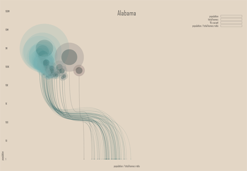
This image doesn't do the interactive nature of the site justice. Click the image to go to the actual site.
Tulp adds his own comments on his website below the instructions:
"There are some interesting things to look for:
counties that have more homes than people
or, counties that have more than 50% vacant homes"
FULL STORY: Ghost Counties

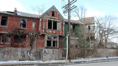
Checking in on Detroit’s Housing Renaissance
Efforts by the city and residents have generated 17,000 new housing units in the last five years.

Baltimore Program Could Repurpose Thousands of Vacant Housing Units
The city and state are investing $3 billion in rescuing vacant residential properties to promote homeownership and reduce blight.

Milwaukee Selects Developers to Rehab Vacant Homes
A record 66 developers applied to refurbish 150 vacant, city-owned homes.

Planetizen Federal Action Tracker
A weekly monitor of how Trump’s orders and actions are impacting planners and planning in America.

Maui's Vacation Rental Debate Turns Ugly
Verbal attacks, misinformation campaigns and fistfights plague a high-stakes debate to convert thousands of vacation rentals into long-term housing.

Restaurant Patios Were a Pandemic Win — Why Were They so Hard to Keep?
Social distancing requirements and changes in travel patterns prompted cities to pilot new uses for street and sidewalk space. Then it got complicated.

In California Battle of Housing vs. Environment, Housing Just Won
A new state law significantly limits the power of CEQA, an environmental review law that served as a powerful tool for blocking new development.

Boulder Eliminates Parking Minimums Citywide
Officials estimate the cost of building a single underground parking space at up to $100,000.

Orange County, Florida Adopts Largest US “Sprawl Repair” Code
The ‘Orange Code’ seeks to rectify decades of sprawl-inducing, car-oriented development.
Urban Design for Planners 1: Software Tools
This six-course series explores essential urban design concepts using open source software and equips planners with the tools they need to participate fully in the urban design process.
Planning for Universal Design
Learn the tools for implementing Universal Design in planning regulations.
Heyer Gruel & Associates PA
JM Goldson LLC
Custer County Colorado
City of Camden Redevelopment Agency
City of Astoria
Transportation Research & Education Center (TREC) at Portland State University
Jefferson Parish Government
Camden Redevelopment Agency
City of Claremont