


At the GeoDesign conference in San Diego we heard mention of folks at MIT using helium balloons with cameras attached to take aerial pictures. Thinking this was a fabulous idea I decided to find out more and see if this was a technique [...]

iPhone Balloon Launch from PlaceMatters' Videos on Vimeo.
At the GeoDesign conference in San Diego we heard mention of folks at MIT using helium balloons with cameras attached to take aerial pictures. Thinking this was a fabulous idea I decided to find out more and see if this was a technique we could easily incorporate into our projects. The MIT connection turned out to be the MIT Center for Future Civic Media and their partnership with others to create Grassroots Mapping, a project and resource site to encourage citizens to use these balloons to generate maps of communities and their surrounding environment.
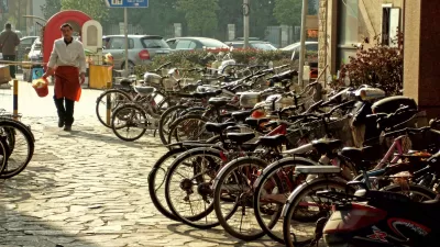
 One application highlighted on the website is Gulf coast communities using the balloons to observe and report on last year's BP oil spill. From Grassroots Mapping emerged the Public Laboratory for Open Technology and Science (PLOTS) which represents network of scientists and activists experimenting with accessible technologies for investigating and reporting on local environmental health and justice issues. PLOTS is a great example of an online platform bringing together citizens, scientists, social scientists, and technologists to collaboratively solve problems. We too see a number of ways we could integrate balloon launches into our work including adding a bird's eye perspective to our Walkshops or providing a unique medium for place-based art projects. The 3 minute video at the top of this blog documents our first balloon launch. Grassroots Mapping's downloadable instructions on how to build your own helium balloon camera made the job easy. At the time, we did not have a digital camera with the functionality of taking continuous pictures so I put huge faith into our knots and fishing line and sent up my iPhone in video mode. Since then we have acquired a GoPro sports camera that is capable of taking video or time-lapse pictures. The GoPro has the added advantage of having a wide angle lens. Total cost for our first balloon launch was $165, with the rental of the helium tank and the purchase of a 6 ft diameter balloon being the dominant expenses. The tank had enough helium for two launches.
Here is a poster of some of the images taken by my iPhone.


Friday Eye Candy: 195 Gigapixels of Urban Glory
An incredibly detailed bird's eye view of Shanghai.
Balloons and Straws: Where's the Connection?
Think "The Graduate," but now the emphasis in the future of plastics may be on restrictions. California may become the first state to restrict access to plastic straws, and balloons could be next due to the harm they cause the marine environment.
New Research Methods Help Nebraska's Water Management Plan
Researchers at the University of Nebraska have been working with the Nebraska Department of Natural Resources to develop best practices for predicting and planning for the future water needs of urban developments.

Planetizen Federal Action Tracker
A weekly monitor of how Trump’s orders and actions are impacting planners and planning in America.

Restaurant Patios Were a Pandemic Win — Why Were They so Hard to Keep?
Social distancing requirements and changes in travel patterns prompted cities to pilot new uses for street and sidewalk space. Then it got complicated.

Map: Where Senate Republicans Want to Sell Your Public Lands
For public land advocates, the Senate Republicans’ proposal to sell millions of acres of public land in the West is “the biggest fight of their careers.”

Maui's Vacation Rental Debate Turns Ugly
Verbal attacks, misinformation campaigns and fistfights plague a high-stakes debate to convert thousands of vacation rentals into long-term housing.

San Francisco Suspends Traffic Calming Amidst Record Deaths
Citing “a challenging fiscal landscape,” the city will cease the program on the heels of 42 traffic deaths, including 24 pedestrians.

California Homeless Arrests, Citations Spike After Ruling
An investigation reveals that anti-homeless actions increased up to 500% after Grants Pass v. Johnson — even in cities claiming no policy change.
Urban Design for Planners 1: Software Tools
This six-course series explores essential urban design concepts using open source software and equips planners with the tools they need to participate fully in the urban design process.
Planning for Universal Design
Learn the tools for implementing Universal Design in planning regulations.
Heyer Gruel & Associates PA
JM Goldson LLC
Custer County Colorado
City of Camden Redevelopment Agency
City of Astoria
Transportation Research & Education Center (TREC) at Portland State University
Camden Redevelopment Agency
City of Claremont
Municipality of Princeton (NJ)