


New earthquake hazard maps from the U.S. Geological Survey show increased earthquake risk areas beyond typical hotspots like California. Geologists say planners and local officials should react to the maps by updating building codes.
"The maps by the U.S. Geological Survey (USGS) reflect the discovery of more earthquake faults in California, a new 7.4-magnitude-quake risk in Utah, as well as more ways to rock the Midwest, South Carolina and the Pacific Northwest than you can shake a stick at."
"Unlike last week's forecast of possible ruptures along faults in California, the National Seismic Hazard Maps calculate the likely intensity of shaking at any given location -- caused by any regional fault giving way -- over a period of 50 years."
"As a result, the new maps are vital for updating local building codes and a direct response to the old geologist truism: Earthquakes don't kill people, buildings kill people."
FULL STORY: Shaky U.S. Grounds Revealed in New Maps

When the Earth Turns to Liquid
A 7.5 magnitude earthquake struck the Indonesian island of Sulawesi on Sept. 25, followed by a massive tsunami. Soil liquefaction caused by the tremor resulted in 1,700 homes being "swallowed" as the soil shifted. Deaths exceeded 1,400 on Oct. 3.

Bay Area Not Prepared for Next Big One
As the death toll from Mexico's 7.1 magnitude earthquake on Sept. 19 climbs above 300, the San Francisco Chronicle investigates how well prepared the Bay Area is for an earthquake of comparable magnitude. Not very well.
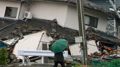
Mexico City Earthquake Should Raise Questions About Building Safety
The epicenter of Tuesday's quake was in the state of Puebla, 80 miles southeast of Mexico City. Soft soil and unreinforced buildings magnified the damage. The quake comes two weeks after an 8.1 quake struck off the coast of the state of Oaxaca.

Planetizen Federal Action Tracker
A weekly monitor of how Trump’s orders and actions are impacting planners and planning in America.

Maui's Vacation Rental Debate Turns Ugly
Verbal attacks, misinformation campaigns and fistfights plague a high-stakes debate to convert thousands of vacation rentals into long-term housing.

Restaurant Patios Were a Pandemic Win — Why Were They so Hard to Keep?
Social distancing requirements and changes in travel patterns prompted cities to pilot new uses for street and sidewalk space. Then it got complicated.

In California Battle of Housing vs. Environment, Housing Just Won
A new state law significantly limits the power of CEQA, an environmental review law that served as a powerful tool for blocking new development.

Boulder Eliminates Parking Minimums Citywide
Officials estimate the cost of building a single underground parking space at up to $100,000.

Orange County, Florida Adopts Largest US “Sprawl Repair” Code
The ‘Orange Code’ seeks to rectify decades of sprawl-inducing, car-oriented development.
Urban Design for Planners 1: Software Tools
This six-course series explores essential urban design concepts using open source software and equips planners with the tools they need to participate fully in the urban design process.
Planning for Universal Design
Learn the tools for implementing Universal Design in planning regulations.
Heyer Gruel & Associates PA
JM Goldson LLC
Custer County Colorado
City of Camden Redevelopment Agency
City of Astoria
Transportation Research & Education Center (TREC) at Portland State University
Jefferson Parish Government
Camden Redevelopment Agency
City of Claremont