A development pattern this lifestyle-defining deserves its whole own classification system.



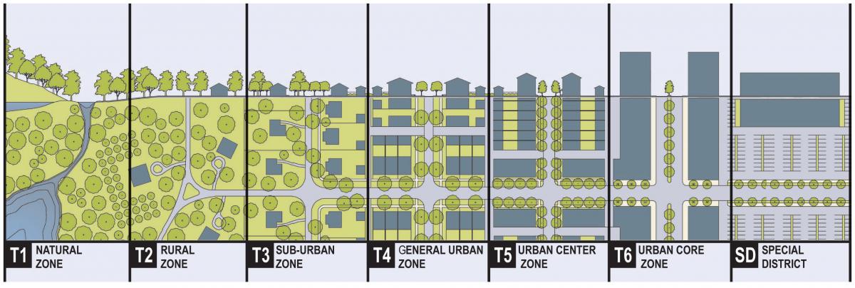
New Urbanists have frequently used the Transect as a way of delineating form-based zoning — that is, zoning that allows a mix of use. In the most versions of the Transect that I have read, T1 and T2 are natural zones, the T3 zone is a suburb-ish zone that is still designed to be more walkable and mixed-use than most of suburbia, T4 and T5 are urban zones a little more intense than T3, and T6 is the most intense urban zone.
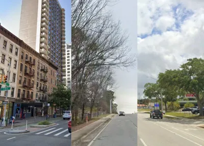
It seems to me that something like the Transect could be used to create a taxonomy of different types of sprawl: for example, from the most walkable to terrifyingly unwalkable. One way of doing this is to distinguish commercial and residential streets.*
'Commercial Sprawl' 1-4
For commercial streets, a sprawl transect would classify different types of stroads (streets that, like limited-access roads, have car traffic that moves too rapidly to be safe for pedestrians). A stroad will typically have speed limits so high that a collision between a car and a pedestrian is likely to kill a pedestrian, or be wide enough to encourage motorists to drive rapidly enough to make such fatalities likely.
Just as the Transect’s T1 and T2 zones are not really urban, the lowest numbered commercial street (let us call it CS1, for “Commercial Sprawl 1”) is arguably not even a stroad. CS1 will be a street with three or four lanes, and thus accommodates dangerously fast car traffic to a greater extent than a true urban street. On the other hand, the danger created by a CS1 street’s width is mitigated by features that calm traffic, such as buildings that are next to a sidewalk and thus create a sense of enclosure for drivers and walkers (arguably slowing down traffic). Other mitigating factors include medians that give walkers a chance to cross the street two lanes at a time, or street trees that create a sense of enclosure. There are many examples of CS1 in New York City. For example, Second Avenue in Manhattan’s Yorkville is wide enough to be a stroad, but certainly feels more walkable to me than most suburban stroads.
Even Manhattan has stroads
CS2 is a garden-variety stroad: a four-lane road without any obvious mitigating features. Such stroads are common in older suburbs, or as minor streets in newer ones. After a few seconds of looking at Google Street View I found 3870 Clairmont Road in the Atlanta suburbs: a stroad with only four lanes, but with no accommodation for walkers beyond sidewalks. Such streets are inhospitable for walkers but could be worse.
A "CS2" in Atlanta
CS3 might include the worst stroads: stroads that are six lanes or more, increasing the length of time a walker crossing the street is exposed to fast-moving traffic. If we want to be more subtle, we could imagine an intermediate CS2.5 zone where the width of the street is mitigated either by medians or by buildings that are close to a sidewalk.
On the other hand, some streets are even worse than a CS3: an eight or ten lane street, or a six-lane street where commercial structures are set back behind parking lots, creating additional crossing time for walkers who wish to shop or work in those structures. I would classify these streets as CS4, but even here a mitigation option is possible. For example, when I lived in Jacksonville my nearest commercial street was at 9800 San Jose Boulevard, a stroad with seven travel lanes but divided by a large median; perhaps San Jose is a still-dangerous CS3.5.
You may need to swirl the image around to see both sides of this stroad...
'Residential Sprawl' 1-4
What about residential streets that are not wide enough to be stroads? It seems to me that the walkability of such a street is governed primarily by three factors: distance to walkable commercial destinations; the existence of interconnected streets that allow people to reach other residences on foot; and the presence or absence of sidewalks, or at least of grass lawns that are walkable in non-rainy weather (at least for able-bodied persons).
As with commercial sprawl, I begin with the borderline case: a residential street that on first glance seems walkable, but is just a bit too far from commercial streets to be in a truly walkable neighborhood. For example, 108 Valentine Street in Highland Park, NJ is an 0.6 mile walk to the nearest commercial street (Raritan Avenue). I would rate this street as RS1 (“Residential Sprawl 1”) — not-quite sprawl but not quite not-sprawl either.
Not quite sprawl, not quite not-sprawl
An RS2 street would be conventional 1920s-1940s proto-suburbia: the sort of residential street where sidewalks are nearly universal and where streets are interconnected enough that most neighbors are easy to reach, but where commercial streets are too far away to be extremely walkable.
For example, in Kansas City’s Country Club District or Dallas’s Highland Park, streets are interconnected and generally have sidewalks, but commercial streets are so far apart that many streets have a Walkscore of 50 or below. I would downgrade a similar street with an unusually low Walkscore (say, 25 or below) to a RS2.5.
Kansas City’s Country Club District
RS3 streets would be typical midcentury suburbia: areas with some shops within walking distance, but where the absence of sidewalks and/or a proliferation of dead-end streets creates a problem for pedestrians. For example, in my brother’s neighborhood in the Toco Hills part of Atlanta, people generally walk on the street because only a few major streets have sidewalks. Nevertheless, these streets are not completely unwalkable because they have grass lawns that a risk-averse pedestrian could use, and because commercial blocks are arguably within walking distance. A grass-lawn street with an extremely low Walkscore (that is, within walking distance of almost nothing) would perhaps be a RS3.5 street.
Toco Hills
The RS4 zone would be the worst-case scenario for anyone on foot: streets (usually in very low-density, estate-home suburbia) where there is not only no sidewalk but also no lawns to walk on, because the woods go right up to the street. An example of an R4 street is the street where my parents lived for many years (parts of Harris Trail in Atlanta).
Sure, you can drive to the estate sale and park on the road... but can you walk from your car to the sale?
The most difficult problem in my classification scheme is presented by streets that seem walkable in isolation because they have sidewalks and/or high Walkscores, but are close to CS3 and CS4 commercial streets. For example, my last apartment in Jacksonville, Fla. was at 3525 Pall Mall Drive, which has a Walkscore of 76 because of its proximity to San Jose Boulevard. My apartment felt very walkable if I was walking to see friends on my side of San Jose, but far less so if I was crossing the street or shopping at stores with giant parking lots. My inclination is to treat these streets as RS2.5 or RS3: still far more walkable than Harris Trail, but less so than a typical RS2 street. Or if I wanted to add more precision but also more complexity, I could describe them as CSM3 (“Commercial Sprawl Mixed Use 3”) or something like that.
San Jose Boulevard at Pall Mall Drive
–
*I note that other commentators have tried to create a Transect of sprawl as a way to address retrofitting sprawl: that is, making it more walkable. The purpose of this post, by contrast, is more like that of Walkscore: to describe the status quo.


Planning for Love, Part 2: What happens to dating in a car-centric world?
A survey of over 150 adults about their dating lives reveals stark differences based on their neighborhood's walkability.
Why Walk Scores Don’t Tell the Whole Story
A popular measure of walkability only measures proximity, not safety or comfort.
Report: Top US Cities for Pedestrian Safety
The East Coast takes the top three spots, while the South and Southwest dominate the bottom of the list.

Planetizen Federal Action Tracker
A weekly monitor of how Trump’s orders and actions are impacting planners and planning in America.

Amtrak, CN end decades-long dispute with eight-year agreement
The new operating agreement establishes an updated framework for the companies to work together, including processes to resolve disputes.
Northwest rail fans eager for Sept. 30 debut of Amtrak’s Airo fleet
Get ready for that new train smell and more seats. But they won’t go faster or run more frequently on the Cascades route in Washington and Oregon.

St. Louis Metro to test if single-car trains can reduce operating costs, maintain rider satisfaction
The pilot program will run from October to spring 2027, and begin with one single-car train operating on Metrolink’s Red and Blue lines.

Pennsylvania is building data centers in abandoned mines
Housing data centers in mines provides an alternative to destroying local forests and may spare residents from data centers’ noise and air pollution.

If Corpus Christi can’t revive desalination plant project, it may owe Texas $235 million
Earlier this month, city officials declined to pursue developing the plant for the second time in a year.

FREE Course: Walkable City 1: Why Walkability?
After describing his path towards focusing on walkability as the essence of good planning, Jeff Speck marches through his five principal reasons for making more walkable places.
Reinventing Malls: Planning Alchemy—Turning Gray Fields Into Gold
The course focuses on the opportunities and imperatives that shape reinvention of mall sites.

City of Thousand Oaks
City of Wisconsin Rapids
Harvard University Graduate School of Design
The Architects Foundation
University of Cincinnati Online
The Pocatello Development Authority
The Urban Renewal Agency of the City of Pocatello

