


Planopedia
Clear, accessible definitions for common urban planning terms.
What Is the Transect?
In urbanism and planning, the term transect provides a conceptual framework for understanding how the scale of built environments can vary from place to place.

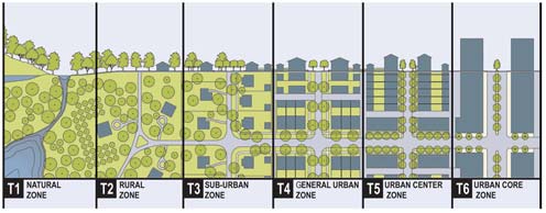
A transect is a visual concept that describes how the scale of human intervention in the environment varies from place to place. The transect cuts a cross section across a spectrum of environments, ranging from completely natural and unspoiled at one end of the spectrum, through exurban and suburban communities, and finally into the varieties of density found in more urban settings at the other end. In the context of planning and urbanism, the transect is most frequently explained with the use of a famous infographic (i.e., an image conveying information, data, or concepts) that splits the natural and built environment into six recognizable, but generic, categories.
The term transect is borrowed from non-planning scientific fields, such as biology and ecology. Researchers working in the field use transects as a linear measure to provide guidance for documenting observations and measurements—a path to move along and record observations. Biologists and ecologists can deploy multiple varieties of transect, including strip transects, line transects, belt transects, point transects, and curved line transects.
In an urbanism and planning context, the transect is frequently associated with the school of planning thought known as New Urbanism. In the context of New Urbanism, the transect is often referred to as the rural-to-urban transect. In the rural-to-urban transect, the depiction of building types and infrastructure vary across the transect, as the recognizable features that make each neighborhood unique emerge from the changing depiction. Thus, the image illustrates recognizable categories in the built environment.The transect also assists in identifying the kinds of built interventions that don't fit with the surrounding environment.
In a form of zoning practice referred to as Transect-Based Zoning, the distinctions along the transect between urban and rural development—varying in the density and intensity of the built additions to the environment—inform the regulations implemented by zoning codes. Based on where along the rural-to-urban transect neighborhoods and districts within cities can be found, transect-based planning will assign the regulations that determine how buildings, lots, land use, street design, and all of the other physical elements of the human-made environment will be built in the future.
New Urbanism designed the rural-to-urban transect as a response to earlier examples of transect, most famously the "Valley Section" created by Patrick Geddes in 1909 and a visualization of the Chimborazo volcano in present-day Ecuador created by Alexander von Humboldt in the early 1800s.

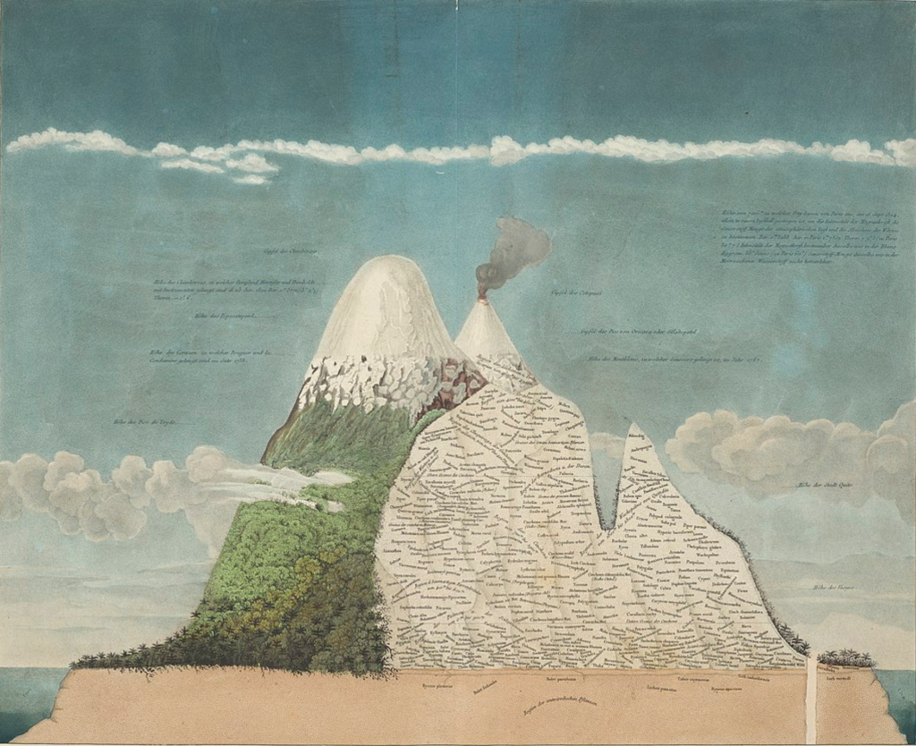
Where Geddes focused on agrarian life, and Humboldt was exploring the natural world, the rural-to-urban transect is intended to inform a new approach to zoning and development, where identifying the surrounding natural and built environment informs the creation of regulations that determine what and how to build in the future. Transect-based zoning is thus a first step toward creating the form-based codes more commonly associated with New Urbanism.
The Center for Transect Studies lists several other varieties of transect, including the European Transect, the American Transect, and the Frontage Transect, in addition to the rural-to-urban transect. Numerous online commentators have applied the transect concept to the varieties of neighborhoods found in their cities. Several versions of a "San Francisco Transect" can be found via Google search, for example.


