


London’s effort to reduce speeds and limit vehicles in parts of the city are contributing to improved road safety.
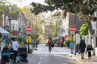
A new study found a 35 percent drop in overall road injuries in one of London’s low-traffic neighborhoods (LTN), areas designed to prioritize people on bikes and on foot.
As Ron Johnson explains in Momentum, “the injury reduction inside LTNs was consistent across different user groups and locations, although the benefit was smaller in outer London LTNs introduced since 2020. Where LTNs were removed, injury levels rose back to pre-intervention rates.” According to the researchers, the LTNs prevented over 600 injuries during the study period.
Further, the analysis addressed a common criticism, that LTNs could potentially shift dangerous traffic to other streets, finding that cyclists and motorcyclists on boundary roads around LTNs also saw a decrease in injury rates.
FULL STORY: Low-Traffic Neighborhoods Cut Serious Road Injuries by a Third, Study Finds


Traffic Reductions in Outer London's 'Mini-Hollands' Curtail Vehicle Ownership
An analysis of areas designated as "low traffic neighborhoods" shows a decrease in vehicle ownership rates, a promising sign for the traffic-choked metropolis.

San Francisco Suspends Traffic Calming Amidst Record Deaths
Citing “a challenging fiscal landscape,” the city will cease the program on the heels of 42 traffic deaths, including 24 pedestrians.

Maryland Plans Quick-Build Complete Streets Projects
The state will use low-cost interventions to improve road safety in five Maryland counties.

Maui's Vacation Rental Debate Turns Ugly
Verbal attacks, misinformation campaigns and fistfights plague a high-stakes debate to convert thousands of vacation rentals into long-term housing.

Planetizen Federal Action Tracker
A weekly monitor of how Trump’s orders and actions are impacting planners and planning in America.

In Urban Planning, AI Prompting Could be the New Design Thinking
Creativity has long been key to great urban design. What if we see AI as our new creative partner?

King County Supportive Housing Program Offers Hope for Unhoused Residents
The county is taking a ‘Housing First’ approach that prioritizes getting people into housing, then offering wraparound supportive services.

Researchers Use AI to Get Clearer Picture of US Housing
Analysts are using artificial intelligence to supercharge their research by allowing them to comb through data faster. Though these AI tools can be error prone, they save time and housing researchers are optimistic about the future.

Making Shared Micromobility More Inclusive
Cities and shared mobility system operators can do more to include people with disabilities in planning and operations, per a new report.
Urban Design for Planners 1: Software Tools
This six-course series explores essential urban design concepts using open source software and equips planners with the tools they need to participate fully in the urban design process.
Planning for Universal Design
Learn the tools for implementing Universal Design in planning regulations.
planning NEXT
Appalachian Highlands Housing Partners
Mpact (founded as Rail~Volution)
City of Camden Redevelopment Agency
City of Astoria
City of Portland
City of Laramie