


In the face of growing flooding risk and increased traffic following the Francis Scott Key Bridge collapse, federal and state officials say protecting two of Baltimore's major transportation corridors from flooding is vital.
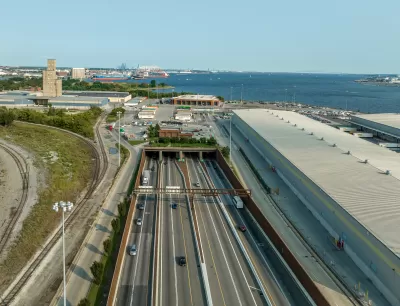
To help manage the risk of coastal flooding from rising sea levels and worsening storms, the U.S. Army Corps of Engineers has recommended building $77 million and 9,500 feet of floodwalls to protect Baltimore’s I-95 Fort McHenry and I-895 Harbor tunnels, two of the city’s major traffic thoroughfares, according to an article from the Baltimore Banner. “The plan comes after USACE and the Maryland Department of Transportation completed a three-year study into coastal flooding problems around Baltimore and potential solutions” and as motorists are using the tunnels as alternative routes following the collapse of the Francis Scott Key Bridge in March, reports Penelope Blackwell.
“It is very important to make sure these critical transportation routes remain open during a coastal storm event, maintaining access to jobs, commercial transportation routes and emergency services,” Joe Bieberich, the project manager for the storm risk study, said in the release.
According to the Baltimore Banner article, the Army Corps and the Maryland Transportation Authority are set to begin design work on the floodwalls later this year, with construction expected to start in 2027, pending congressional authorization and funding.
FULL STORY: Army Corps recommends $77M floodwall to protect Baltimore’s tunnels from storms


Delaware to Invest $15M in Coastal Resilience
State officials say they’re moving forward with emergency repair and renourishment of sand dunes around the Indian River Inlet Bridge as they await a promised $10 million federal contribution.

Houston’s ‘Ike Dike’ Won’t Adequately Protect the City
The largest project ever undertaken by the Army Corps of Engineers may not be enough to protect Houston-area communities from flooding during the most severe hurricanes, according to the Corps’ own analysis.
FEMA Flood Insurance Updates Reflect Actual Risk to Each Home
Changes to how FEMA calculates flood risk will assess risk at a home-by-home level, rather than estimating the same risk to all homes in the same floodplain.

Planetizen Federal Action Tracker
A weekly monitor of how Trump’s orders and actions are impacting planners and planning in America.

Congressman Proposes Bill to Rename DC Metro “Trump Train”
The Make Autorail Great Again Act would withhold federal funding to the system until the Washington Metropolitan Area Transit Authority (WMATA), rebrands as the Washington Metropolitan Authority for Greater Access (WMAGA).

DARTSpace Platform Streamlines Dallas TOD Application Process
The Dallas transit agency hopes a shorter permitting timeline will boost transit-oriented development around rail stations.

LA County Creating Action Plan to Tackle Extreme Heat
Los Angeles County is creating a Heat Action Plan to help communities stay safe during extreme heat, with steps like adding more shade, improving buildings, and supporting the neighborhoods most at risk.

Maryland Plans Quick-Build Complete Streets Projects
The state will use low-cost interventions to improve road safety in five Maryland counties.

Downtown Los Angeles Gears Up for Growth
A new report highlights Downtown L.A.’s ongoing revival through major housing projects, adaptive reuse, hospitality growth, and preparations for global events in the years ahead.
Urban Design for Planners 1: Software Tools
This six-course series explores essential urban design concepts using open source software and equips planners with the tools they need to participate fully in the urban design process.
Planning for Universal Design
Learn the tools for implementing Universal Design in planning regulations.
City of Charlotte
Municipality of Princeton
Roanoke Valley-Alleghany Regional Commission
City of Camden Redevelopment Agency
City of Astoria
Transportation Research & Education Center (TREC) at Portland State University
US High Speed Rail Association
City of Camden Redevelopment Agency
Municipality of Princeton (NJ)