


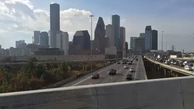
A chapter in a new book highlights how highway construction forced changes and caused displacement in communities that included public housing developments.

In an adapted excerpt from Justice and the Interstates: The Racist Truth About Urban Highways published in Next City, Kyle Shelton director of the University of Minnesota Center for Transportation Studies, describes the generational impacts of highway construction on communities and public housing developments in Houston, Texas.
“With every road widening, communities changed. Landscapes shifted. Routes to work and school were blocked. Homes and community institutions were displaced. Although the residents absorbed these impacts for generations, at no point have these Houstonians had the chance to meaningfully shape the highway projects that affect them.”
Shelton details the history of Clayton Homes and Kelly Village, which continue to face environmental hazards and reduced mobility. Yet the Texas Department of Transportation (TxDOT) is plowing ahead with the North Houston Highway Improvement Project (NHHIP), a freeway expansion that threatens to displace hundreds of homes and businesses.
Of course, “This story is repeated across the nation in highway-side communities, most of which are home to low-income and non-white residents. The highways set, in concrete, the course of decades of infrastructure development along with the same, ever-wider rights of way.”
Shelton argues that with many of the country’s major roads and highways aging, now is the time to reevaluate their role in the transportation system. “The choices cities, states, and the federal government make in the coming years can either exacerbate the negative impacts felt by highway-side residents or begin to center alternative approaches and transportation strategies that improve our collective mobility and address the wounds created by past decisions.”
FULL STORY: Houston’s Disruptive History Of Highways, And What Transit Agencies Can Do Better

Contentious Houston Freeway Widening Project Inches Forward
Federal officials have given TxDOT the go-ahead to resume work on a small portion of a controversial interstate widening project in downtown Houston.
Proposed Park Yet Another Hurdle for Houston Interstate Expansion
The Interstate 45 widening project, halted by a federal order and opposed by many local officials and organizations, could hit a new snag if White Oak Bayou becomes a city park.
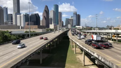
TxDOT Faces Lawsuit from Harris County Over I-45 Plan
The lawsuit over the controversial I-45 project, which has been plagued by local opposition, calls for a new environmental review.

Maui's Vacation Rental Debate Turns Ugly
Verbal attacks, misinformation campaigns and fistfights plague a high-stakes debate to convert thousands of vacation rentals into long-term housing.

Planetizen Federal Action Tracker
A weekly monitor of how Trump’s orders and actions are impacting planners and planning in America.

In Urban Planning, AI Prompting Could be the New Design Thinking
Creativity has long been key to great urban design. What if we see AI as our new creative partner?

King County Supportive Housing Program Offers Hope for Unhoused Residents
The county is taking a ‘Housing First’ approach that prioritizes getting people into housing, then offering wraparound supportive services.

Researchers Use AI to Get Clearer Picture of US Housing
Analysts are using artificial intelligence to supercharge their research by allowing them to comb through data faster. Though these AI tools can be error prone, they save time and housing researchers are optimistic about the future.

Making Shared Micromobility More Inclusive
Cities and shared mobility system operators can do more to include people with disabilities in planning and operations, per a new report.
Urban Design for Planners 1: Software Tools
This six-course series explores essential urban design concepts using open source software and equips planners with the tools they need to participate fully in the urban design process.
Planning for Universal Design
Learn the tools for implementing Universal Design in planning regulations.
planning NEXT
Appalachian Highlands Housing Partners
Gallatin County Department of Planning & Community Development
Mpact (founded as Rail~Volution)
City of Camden Redevelopment Agency
City of Astoria
City of Portland
City of Laramie