


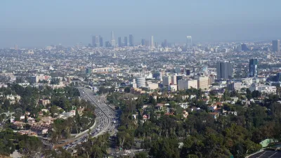
A new mapping tool underscores inequities in infrastructure that lead to higher rates of heat-related illnesses in low-income neighborhoods.

A new mapping tool from UCLA that tracks heat-related emergency room visits in Los Angeles County “highlights a stark disparity between wealthier, leafier neighborhoods and those that are home to fewer trees, more concrete and higher occurrences of underlying health issues.” Hayley Smith reports on the map’s findings for the Los Angeles Times. “Although extreme heat has become the leading cause of weather-related deaths in the United States, a Times investigation found that such deaths are chronically undercounted.”
According to the map, some parts of Los Angeles see as much as four times as many emergency room visits due to extreme heat. “The parts of L.A. County that show higher rates of ER visits during heat days include the South L.A. corridor down to the ports, the San Pedro area, and the northwest Valley, especially San Fernando and Pacoima, said Eisenman, who is also a professor at the UCLA Fielding School of Public Health.”
A county Climate Vulnerability Assessment released last fall found that extreme heat could increase by as much as ten times in the next two decades. “[David Eisenman, co-director of the UCLA Center for Public Health and Disasters] said the findings in L.A. County are in some ways not surprising in that they echo the ‘decades of redlining’ that have led to differences in shade, access to air conditioning and even base-line health levels in some L.A. communities. Redlining was the institutional practice of denying homeownership and financial services to residents based on race.” Eisenman also points out that heat exacerbates underlying conditions like diabetes and heart disease.
The city of L.A.’s new “chief heat officer,” Marta Segura, says her office is working to create an early warning system for heat waves and implement long-term strategies for reducing heat exposure, including planting more trees and updating building codes.
FULL STORY: How dangerous is extreme heat in your neighborhood? This map tells you

Updating LA’s Tree Rules Could Bring More Shade to Underserved Neighborhoods
A new USC study finds that relaxing Los Angeles’ outdated tree planting guidelines could significantly expand urban tree canopy and reduce shade disparities in lower-income neighborhoods, though infrastructure investments are also needed.

How Extreme Heat Impacts Heart Health
A higher number of high heat days correlates with more cardiovascular deaths, according to new research.

To Combat Rising Heat Deaths, Phoenix Creates Heat Response and Mitigation Office
As more extreme temperatures lead to an alarming rise in heat-related deaths across the country, Phoenix is taking action with the nation's first public heat response office.

Trump Administration Could Effectively End Housing Voucher Program
Federal officials are eyeing major cuts to the Section 8 program that helps millions of low-income households pay rent.

Planetizen Federal Action Tracker
A weekly monitor of how Trump’s orders and actions are impacting planners and planning in America.

Canada vs. Kamala: Whose Liberal Housing Platform Comes Out on Top?
As Canada votes for a new Prime Minister, what can America learn from the leading liberal candidate of its neighbor to the north?

Washington State’s Parking Reform Law Could Unlock ‘Countless’ Acres for New Housing
A law that limits how much parking cities can require for residential amd commercial developments could lead to a construction boom.

Wildlife Rebounds After the Eaton Fire
Following the devastation of the Eaton Fire, the return of wildlife and the regrowth of native plants are offering powerful signs of resilience and renewal.

LA to Replace Inglewood Light Rail Project With Bus Shuttles
LA Metro says the change is in response to community engagement and that the new design will be ready before the 2028 Olympic Games.
Urban Design for Planners 1: Software Tools
This six-course series explores essential urban design concepts using open source software and equips planners with the tools they need to participate fully in the urban design process.
Planning for Universal Design
Learn the tools for implementing Universal Design in planning regulations.
Central Transportation Planning Staff/Boston Region MPO
Heyer Gruel & Associates PA
Institute for Housing and Urban Development Studies (IHS)
City of Grandview
Harvard GSD Executive Education
Regional Transportation Commission of Southern Nevada
Toledo-Lucas County Plan Commissions