


A new study shows a disparity between the frequency of crosswalks in San Francisco's northern and southern neighborhoods.
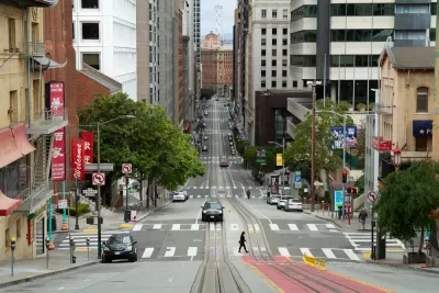
Heather Knight reports on a new study from Marcel Maron, who analyzed all of San Francisco's 6,399 intersections and mapped the existence or lack of crosswalks at each one. Maron's results showed a stark disparity between neighborhoods. "Crosswalk hot spots with clusters of intersections sporting the painted passages are almost entirely located in the northern half of the city, particularly in richer neighborhoods including Pacific Heights, Presidio Heights, Laurel Heights, Alamo Square, Nob Hill, the Financial District and South Beach." Meanwhile, "Crosswalk cold spots, where pedestrians can walk blocks without encountering a crosswalk, are almost entirely in the southern half of the city."
Overall, 58% of San Francisco’s intersections have crosswalks, but their distribution varies widely. In Pacific Heights, 83% of intersections have them, while in Bayview-Hunters Point, 51% do. In the Mission, which has far more traffic and pedestrians than Pacific Heights, 63% of intersections have crosswalks.
Another study Moran conducted in 2020 analyzed the city's nearly 3,000 bus stops and found a similar disparity in amenities like seating, shelters, and signage between the northern and southern halves of the city. "Also, routes with the longest intervals between buses were the least likely to have seats and shelters — making passengers who have to wait the longest do so in the least comfortable way. This, again, despite San Francisco’s claim to be a transit-first city," notes Knight.
Moran argues that these disparities create a vicious cycle, discouraging people from walking or using transit due to safety and comfort concerns. "And then the city can say better bus stops and crosswalks aren’t necessary because people aren’t using those spaces."
FULL STORY: He mapped every crosswalk in S.F. The results show a startling safety gap for some neighborhoods

Connecticut Launches Complete Streets Standards
The new policy calls for sidewalks, bike lanes, and crosswalks on state roads and state-funded road projects.
San Francisco Slow Streets Bucks Citywide Trend, Reducing Injuries by 61 Percent
Low-cost interventions aimed at slowing traffic are making a major impact on road safety.
NACTO Releases Updated Urban Bikeway Guide
The third edition of the nationally recognized road design guide includes detailed design advice for roads that prioritize safety and accessibility for all users.

Planetizen Federal Action Tracker
A weekly monitor of how Trump’s orders and actions are impacting planners and planning in America.

Canada vs. Kamala: Whose Liberal Housing Platform Comes Out on Top?
As Canada votes for a new Prime Minister, what can America learn from the leading liberal candidate of its neighbor to the north?

The Five Most-Changed American Cities
A ranking of population change, home values, and jobs highlights the nation’s most dynamic and most stagnant regions.

San Diego Adopts First Mobility Master Plan
The plan provides a comprehensive framework for making San Diego’s transportation network more multimodal, accessible, and sustainable.

Housing, Supportive Service Providers Brace for Federal Cuts
Organizations that provide housing assistance are tightening their purse strings and making plans for maintaining operations if federal funding dries up.

Op-Ed: Why an Effective Passenger Rail Network Needs Government Involvement
An outdated rail network that privileges freight won’t be fixed by privatizing Amtrak.
Urban Design for Planners 1: Software Tools
This six-course series explores essential urban design concepts using open source software and equips planners with the tools they need to participate fully in the urban design process.
Planning for Universal Design
Learn the tools for implementing Universal Design in planning regulations.
Central Transportation Planning Staff/Boston Region MPO
Heyer Gruel & Associates PA
Institute for Housing and Urban Development Studies (IHS)
City of Grandview
Harvard GSD Executive Education
Regional Transportation Commission of Southern Nevada
Toledo-Lucas County Plan Commissions