


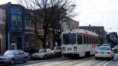
A report from the Brookings Institution shows how planners can use new types of anonymized data to inform mobility planning decisions.

A recently published Brookings Institution report, titled "Connecting people and places: Exploring new measures of travel behavior," uses data derived from geolocation sources to analyze information about patterns of travel in six U.S. metropolitan areas.
Thanks to such sources as cell phone data and shared bike platforms, planners now have access to data that could be used to shed light on mobility, reports Bill Lucia. The researchers responsible for the Brookings report assert that the use of this data in planning practice is not only beneficial on the individual level, but also to society at large.
Lucia writes:
The ideas raised in the report tie back to longstanding, and sometimes contentious, policy issues in areas like housing affordability, racial and income inequality, transit, and the legacy of how America has built and reworked cities and suburbs over decades of time.
But the way the researchers tap into the geolocation data to provide a foundation for their analysis underscores how state and local agencies might use this type of information in similar ways to inform policy decisions and discussions surrounding these issues.
The data used in the report was collected and anonymized by the company Replica. Researchers at the Brookings Institution's Metropolitan Policy Program fellow Adie Tomer is quoted in the article saying that the research reveals the power of location data to inform new choices for mobility planning.
FULL STORY: Geolocation Data Could Help Planners Design Communities that Require Less Driving


A Compact, Connected, Clean, and Inclusive Recovery for Mexico
As the Mexican government charts the country’s recovery from COVID-19, a newly published paper charts national solutions to urban transportation and housing challenges that will put Mexico’s cities on a path to prosperity and resilience.

Austin Strategic Mobility Plan Final Draft Released
The first priority of the draft Austin Strategic Mobility Plan is to reduce single-occupant vehicle trips.
Philadelphia's First Strategic Transportation Plan Released
Getting serious about mobility and traffic safety in the City of Brotherly Love.

Planetizen Federal Action Tracker
A weekly monitor of how Trump’s orders and actions are impacting planners and planning in America.

DARTSpace Platform Streamlines Dallas TOD Application Process
The Dallas transit agency hopes a shorter permitting timeline will boost transit-oriented development around rail stations.

Congressman Proposes Bill to Rename DC Metro “Trump Train”
The Make Autorail Great Again Act would withhold federal funding to the system until the Washington Metropolitan Area Transit Authority (WMATA), rebrands as the Washington Metropolitan Authority for Greater Access (WMAGA).

Supreme Court Ruling in Pipeline Case Guts Federal Environmental Law
The decision limits the scope of a federal law that mandates extensive environmental impact reviews of energy, infrastructure, and transportation projects.

Texas State Bills to Defund Dallas Transit Die
DART would have seen a 30% service cut, $230M annual losses had the bills survived.

Bikeshare for the Win: Team Pedals to London Cricket Match, Beats Rivals Stuck in Traffic
While their opponents sat in gridlock, England's national cricket team hopped Lime bikes, riding to a 3-0 victory.
Urban Design for Planners 1: Software Tools
This six-course series explores essential urban design concepts using open source software and equips planners with the tools they need to participate fully in the urban design process.
Planning for Universal Design
Learn the tools for implementing Universal Design in planning regulations.
Roanoke Valley-Alleghany Regional Commission
City of Mt Shasta
City of Camden Redevelopment Agency
City of Astoria
Transportation Research & Education Center (TREC) at Portland State University
US High Speed Rail Association
City of Camden Redevelopment Agency
Municipality of Princeton (NJ)