The subdivision process imposes rules that result in a lack flexibility, convoluted urban design, and diced up landscapes.


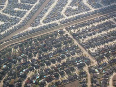
Ray Dubicki argues subdivision and the parceling of land should get as much attention as zoning when examining how cities are shaped. "Once a lot is created through subdivision, it never gets unmade. Subdivision leaves a paper trail burdened with the weight of the past and creating a significant barrier to change. That barrier gets higher and higher as we shred city land into the tiniest possible atoms."
Dubicki says the decisions related to subdivision can create less-than-ideal results that are permanent. "There is a reason that the building industry refers to the results of subdivision approvals as 'entitlements.' They are court enforceable rulings on the intensity of development and limits to what the city is asking for. Builders plug this into their accounting to figure out profit and loss. The jurisdiction’s hands are then tied."
Subdivision also hinders denser developments by creating smaller and smaller parcels that are then more difficult to consolidate for larger multi-family buildings. In addition, parcels such as "flag lots," requiring long, shared driveways for access to a public road, create "puzzle piece subdivisions," says Dubicki.
"Perhaps our challenge is to move our subdivision mindset away from the simple parceling out of land and entitlements. The flat, indelible lines of subdivision are just as inflexible as the old flat LEGO baseplates. We are developing newer ways of thinking about layers of space in our cities, including different methods of ownership and the ways they impact our communities," adds Dubicki.
Update: At the end of his article on subdivision, Dubicki asked readers to nominate the strangest lot lines in the Seattle areas. He has compiled the most bizarre lot winners, including the Olympic Hammerhead, Sammamish Crop Circles, and the Land Meander.
Read the full story: The Lines We Draw: Subdivision
Yet again, Seattle’s density zoning update is hit with delays
The city must now examine the ‘maximum possible development’ under a future zoning scenario, rather than the ‘maximum likely development.’
Seattle Adopts a New Growth Plan, but Major Zoning Battles are Just Beginning
Approving the comprehensive plan update is just the first step in rewriting the city’s zoning code to accommodate more density and affordable housing.
Seattle’s Zoning Reform Could Unlock a ‘Multiplex Boom’
A package of stackable density bonuses could make it easier for developers to build 12-plexes.

Planetizen Federal Action Tracker
A weekly monitor of how Trump’s orders and actions are impacting planners and planning in America.

California plans to bury El Niño’s downpour
If the state plays its cards right, it may be able to store a billion acre-feet of El Niño’s water in aquifers.

Desperate measures: Advocates weigh draining Lake Powell to fill Colorado River
Draining the reservoir could reduce evaporation losses by a couple hundred thousand acre-feet.

Housing is the top priority of Seattle’s sole new councilmember
Jenks campaigned on building 1,000 new units of affordable housing.

New tax cuts may slash $1.5 billion in funding for Miami transit, public parks
Amendment 3 will save Miami-Dade homeowners $2,700 in 2028.

Arizona, Wisconsin, Pennsylvania hope to finally advance climate goals post-midterms
The three states have spent years under Republican or divided control.

FREE Course: Walkable City 1: Why Walkability?
After describing his path towards focusing on walkability as the essence of good planning, Jeff Speck marches through his five principal reasons for making more walkable places.
Reinventing Malls: Planning Alchemy—Turning Gray Fields Into Gold
The course focuses on the opportunities and imperatives that shape reinvention of mall sites.

City of Rosemead
Rutgers University, Edward J. Bloustein School of Planning and Public Policy
One Hundred Miles
University of Michigan School for Environment and Sustainability (SEAS)
Hunter College, City University of New York (CUNY)
The Architects Foundation
City of Cambridge
Montrose County
The Pocatello Development Authority