


Urban trees play an essential role in making cities livable and countering the effects of climate change.

Oliver Balch reports on the role of urban trees in cities around the world. The measures and data sources used to measure canopy cover can vary, which means rankings differ as well. In addition, experts say that absolute measures of tree numbers should not be the sole focus. "Access to trees, not their quantity, is what really matters, [Simone Borelli] argues. Can city-dwellers sense, see or, ideally, touch the trees in their city?"
The factors behind high levels of tree coverage in cities are a combination of geographic location and public policy. In Singapore, for example, planting and maintaining trees and green spaces are policy priorities included in development plans. "There are about 7 million trees in Singapore, approximately 3 million of which are along streets, in parks, residential and industrial estates. And [National Parks Board] has stepped up efforts in recent years by planting more than 50,000 trees a year along roadsides, and in parks and gardens," says Balch.
And while many cities recognize the importance of tree canopies, trees have become environmental casualties of development in other cities. In Atlanta, over half a million acres of trees were lost between 1973 and 1999 as the city grew. "Another case in point, environmentalists argue, is the proposed £88bn fast-rail HS2 project in Britain. In September, green campaign groups called on the pending clearance of ancient woodlands to be paused until the results of an independent review are published," notes Balch.
FULL STORY: Green streets: which city has the most trees?


The Ongoing Debate Over California's Eucalyptus Trees
The eucalyptus is an exotic species in California, and studies suggest it has contributed to an increase in wildfire hazards. But defenders of the trees say the eucalyptus is just an ecological scapegoat.
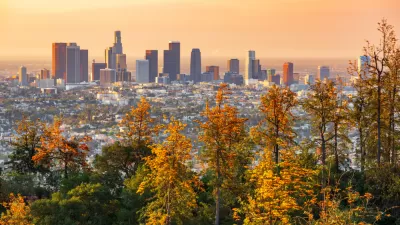
LA’s Trees Absorb More Carbon Than Expected, But Can’t Do It Alone
A USC study finds that Los Angeles’ urban trees absorb more carbon than expected, but while they provide crucial environmental benefits, they cannot replace the urgent need for systemic emissions reductions.
Global Report Shows Urban Forests Failing to Meet Vital Standards
The study reveals significant gaps in urban forestry, emphasizing the urgent need for reforms, innovative planting solutions, and expanded tree canopy to combat climate change and improve urban health.

Rethinking Redlining
For decades we have blamed 100-year-old maps for the patterns of spatial racial inequity that persist in American cities today. An esteemed researcher says: we’ve got it all wrong.

Planetizen Federal Action Tracker
A weekly monitor of how Trump’s orders and actions are impacting planners and planning in America.

Walmart Announces Nationwide EV Charging Network
The company plans to install electric car chargers at most of its stores by 2030.

Seattle’s Pike Place Market Leans Into Pedestrian Infrastructure
After decades of debate, the market is testing a car ban in one of its busiest areas and adding walking links to the surrounding neighborhood.

The World’s Longest Light Rail Line is in… Los Angeles?
In a city not known for its public transit, the 48.5-mile A Line is the longest of its kind on the planet.

Quantifying Social Infrastructure
New developments have clear rules for ensuring surrounding roads, water, and sewers can handle new users. Why not do the same for community amenities?
Urban Design for Planners 1: Software Tools
This six-course series explores essential urban design concepts using open source software and equips planners with the tools they need to participate fully in the urban design process.
Planning for Universal Design
Learn the tools for implementing Universal Design in planning regulations.
City of Moorpark
City of Tustin
City of Camden Redevelopment Agency
City of Astoria
Transportation Research & Education Center (TREC) at Portland State University
Regional Transportation Commission of Southern Nevada
Toledo-Lucas County Plan Commissions