


The measures of urbanization vary widely, and the differences pose a challenge in developing policies and plans for cities.
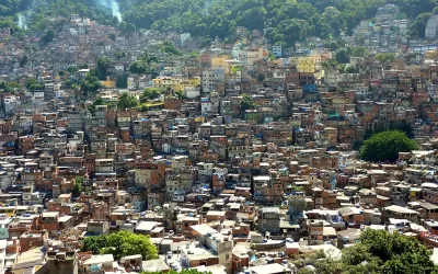
Richard Florida considers the various ways in which levels of urbanism have been defined and measured. United Nations estimates say 55 percent of the global population is urban. But a new report from the European Commission puts this figure at 84 percent. The report also found higher urban levels in Asia and Africa.
The differences stem from the variety of ways urbanization is reported country by country, says Florida:
According to the EC group, about half of countries define urban based on a minimum population size threshold—85 percent of countries use a threshold of 5,000 people or fewer but other countries have dramatically higher requirements, like Mali’s 30,000, Japan’s 50,000, or China’s 100,000. Only a few countries use population density as a measure of urbanization.
However, researchers from New York University say the European Commission figures are too high and the 55 percent figure is more accurate. "[Shlomo] Angel believes the most effective way to gauge urbanization is not through population or density per se, but by looking at contiguous built-up areas of 100,000 or more people," reports Florida.
Florida argues that better, more consistent standards and analysis are essential for developing effective policy. "The research, data, and urban science we have on the world’s cities and urban areas is troublingly inadequate. If building better, more resilient, more sustainable, and more prosperous cities is key to our future global well-being, it is critical that we do much better."
FULL STORY: Just How Much of the World Is Urban?


The Consequences of Urban Population Decline for American Cities
Big cities saw the sharpest population declines during the pandemic. Is the trend here to stay?

10,000 Cities—and Counting
A novel approach to quantifying the world's urban population provides insight into a changing world.

New Report Contradicts the U.N.: More Like 84 Percent of the World Lives in Urban Areas
"Everything we've heard about global urbanization turns out to be wrong."

Montreal Mall to Become 6,000 Housing Units
Place Versailles will be transformed into a mixed-use complex over the next 25 years.

Planetizen Federal Action Tracker
A weekly monitor of how Trump’s orders and actions are impacting planners and planning in America.

DARTSpace Platform Streamlines Dallas TOD Application Process
The Dallas transit agency hopes a shorter permitting timeline will boost transit-oriented development around rail stations.

Interactive Map Reveals America's “Shade Deserts”
Launched by UCLA and American Forests to combat heat-related deaths, the tool maps the shade infrastructure for over 360 U.S. cities.

Bicycles and Books — In Sacramento, Libraries Now Offer Both
Adult library card holders can check out e-bikes and e-trikes for up to one week.

Colorado Landfills Emit as Much Pollution as 1M Cars
Landfills are the third-largest source of methane pollution in Colorado, after agriculture and fossil fuel extraction.
Urban Design for Planners 1: Software Tools
This six-course series explores essential urban design concepts using open source software and equips planners with the tools they need to participate fully in the urban design process.
Planning for Universal Design
Learn the tools for implementing Universal Design in planning regulations.
City of Mt Shasta
City of Camden Redevelopment Agency
City of Astoria
Transportation Research & Education Center (TREC) at Portland State University
US High Speed Rail Association
City of Camden Redevelopment Agency
Municipality of Princeton (NJ)