The light rail line was supposed to improve transit to less accessible parts of the city, but service so far has been disappointing.


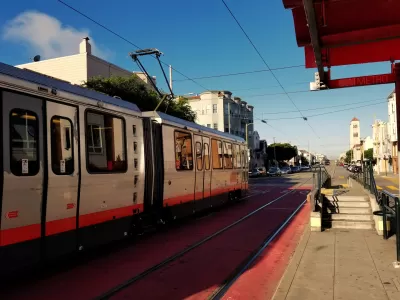
Rachel Swan reports on the T-Third Street Muni light rail line in San Francisco. The line runs through communities along the eastern side of the city, many of which are growing quickly. It was pitched as an alternative to local bus service and a quick and efficient way to move people from some of the city’s more far-flung neighborhoods.
But soon after the line opened in 2007, it was plagued with delays that have continued:
The T line’s problems appear to stem from its design. It hits about 60 intersections looping from Sunnydale to the Folsom portal, where it travels underground to Embarcadero Station and then changes signs to become the K-Ingleside. Most of those intersections have traffic signals that don’t always sync up to give trains priority over other vehicles.
In addition, says Swan, trains are slowed down by cars making illegal left-hand turns and on parts of route where trains share roads crowded with vehicle traffic.
Plans to improve service include using software to help trains get through lights and intersections more easily, addressing problem points on the route, and increasing train capacity by adding additional cars.
With the rapid growth in development in neighborhoods along the route and the demand in ridership that will result, whether these changes will fix the T line’s problems remains to be seen. In addition, residents say 23rd Street in the Dogpatch neighborhood marks the end of gentrification in the area, and they wonder if service improvements will benefit lower-income and more isolated communities to the south.
“Even so, politicians and transit officials still champion the T as a great social equalizer, saying it could pump business into the city’s most neglected neighborhoods and give those residents a quick link to the downtown core,” says Swan.
Read the full story: The T line has never lived up to its promise. Coming upgrades may not be enough to help
SF’s Muni Transit Slashes Budget as it Approaches Fiscal Cliff
The transit agency, which faces a $322 million budget deficit, has pledged to preserve current routes and schedules, but is making other cuts across the board.
Long Delayed, $1.95 Billion Central Subway Opens in San Francisco
San Francisco’s first north-south subway opened last weekend, extending service on Muni’s T light rail line.
Post-Pandemic Transit Plan Announced in San Francisco
The recently announced post-COVID plan for public transit in San Francisco looks a lot different than the pre-COVID days.

Planetizen Federal Action Tracker
A weekly monitor of how Trump’s orders and actions are impacting planners and planning in America.

California plans to bury El Niño’s downpour
If the state plays its cards right, it may be able to store a billion acre-feet of El Niño’s water in aquifers.

Desperate measures: Advocates weigh draining Lake Powell to fill Colorado River
Draining the reservoir could reduce evaporation losses by a couple hundred thousand acre-feet.

US buildings threatened, destroyed by fires set to triple by 2060
Researchers found a high fire risk for socioeconomically vulnerable neighborhoods in the American West.

LA residents may be allowed to paint their own crosswalks
Councilwoman Katy Yaroslavsky put out a motion instructing the Los Angeles Department of Public Transportation to study the feasibility of allowing volunteers to paint crosswalks.

Dallas moves to overhaul its zoning code
The city's zoning reform will allow more multi-family and mixed-use developments.

FREE Course: Walkable City 1: Why Walkability?
After describing his path towards focusing on walkability as the essence of good planning, Jeff Speck marches through his five principal reasons for making more walkable places.
Reinventing Malls: Planning Alchemy—Turning Gray Fields Into Gold
The course focuses on the opportunities and imperatives that shape reinvention of mall sites.

City of Rosemead
Rutgers University, Edward J. Bloustein School of Planning and Public Policy
One Hundred Miles
Hunter College, City University of New York (CUNY)
The Architects Foundation
University of Cincinnati Online
City of Cambridge
Montrose County
The Pocatello Development Authority