


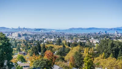
Tree-D Fusion, an AI-driven tool developed by MIT and Purdue researchers, generates 3D models of urban trees to help city planners visualize future green spaces, address climate challenges, and enhance urban livability and sustainability.

Tree-D Fusion, a groundbreaking system developed by researchers including the Massachusetts Institute of Technology (MIT)'s Sara Beery and Purdue University's Jae Joong Lee, uses AI to create 3D models of urban trees from 2D images, such as those from Google Street View. This tool leverages species- and environment-specific data to simulate realistic tree growth and predict how urban forests will evolve over time. Beyond visualizing the future of green spaces, the system offers cities a "living digital forest" to monitor environmental stresses and assess tree health, helping urban planners proactively manage tree growth and avoid issues like interference with power lines.
The technology also addresses broader urban challenges, such as combating the heat island effect and improving city livability amid climate change. By mapping intricate shade patterns and envisioning future green spaces, Tree-D Fusion enables planners to strategically cultivate urban forests that can cool cities and mitigate heat buildup. These efforts align with studies showing that access to green spaces significantly impacts public health, life expectancy, and social equity, emphasizing the importance of incorporating urban forestry into city planning.
Looking to the future, the creators of Tree-D Fusion aim to scale the platform globally, using AI insights to promote biodiversity, sustainability, and ecosystem health. Alongside complementary research, such as studies on the number of trees needed to cool cities like Los Angeles, the system exemplifies how technology can merge with ecological science to create greener, more resilient urban environments that benefit both people and the planet.
FULL STORY: Hey Google: Data Scientists Use AI to Plant New Forests in the Cities


A Framework for Inclusive Tree Planting in Los Angeles
The Los Angeles Urban Forest Equity Collective has developed an equity-centered tree-planting framework and toolkit to address historic underinvestment and mitigate extreme heat in vulnerable neighborhoods.

A Plan to Expand Tree Canopy Across Dayton
Dayton is developing an urban forest master plan, using a $2 million grant to expand its tree canopy, address decades of tree loss, and enhance environmental equity across the city.
Oakland Adopts Urban Forest Plan to Foster Equity and Environmental Justice
The Oakland City Council has adopted its first Urban Forest Plan, a 50-year roadmap focused on equitable tree care, canopy preservation, and environmental justice to benefit underserved communities.

Maui's Vacation Rental Debate Turns Ugly
Verbal attacks, misinformation campaigns and fistfights plague a high-stakes debate to convert thousands of vacation rentals into long-term housing.

Planetizen Federal Action Tracker
A weekly monitor of how Trump’s orders and actions are impacting planners and planning in America.

In Urban Planning, AI Prompting Could be the New Design Thinking
Creativity has long been key to great urban design. What if we see AI as our new creative partner?

King County Supportive Housing Program Offers Hope for Unhoused Residents
The county is taking a ‘Housing First’ approach that prioritizes getting people into housing, then offering wraparound supportive services.

Researchers Use AI to Get Clearer Picture of US Housing
Analysts are using artificial intelligence to supercharge their research by allowing them to comb through data faster. Though these AI tools can be error prone, they save time and housing researchers are optimistic about the future.

Making Shared Micromobility More Inclusive
Cities and shared mobility system operators can do more to include people with disabilities in planning and operations, per a new report.
Urban Design for Planners 1: Software Tools
This six-course series explores essential urban design concepts using open source software and equips planners with the tools they need to participate fully in the urban design process.
Planning for Universal Design
Learn the tools for implementing Universal Design in planning regulations.
planning NEXT
Appalachian Highlands Housing Partners
Mpact (founded as Rail~Volution)
City of Camden Redevelopment Agency
City of Astoria
City of Portland
City of Laramie