


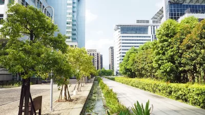
A new tool can help cities understand the benefits of tree planting efforts at the municipal scale.

A new study from researchers from the Chinese Academy of Sciences and the Cary Institute of Urban Ecosystem Studies offers a way to understand the benefits of urban trees at larger scales so they can make more informed decisions about tree planting programs aimed at reducing urban temperatures and improving air quality.
“Overall, the team discovered that the cooling efficiency of urban trees increased at larger scales,” in part thanks to the ability to plant larger groups of trees. “For example, the authors estimate that the city of Baltimore could reduce land surface temperatures by 0.23°C if they increased tree canopy by 1%. To achieve 1.5°C of cooling, they would need to increase tree canopy cover by 6.39%.”
With greater clarity about the relationships between area, tree canopy cover, and cooling effects, the paper makes it possible to predict cooling effects at the whole-city scale, offering a valuable tool for managers to set urban tree canopy goals to reduce extreme heat.
One of the study’s authors points out that while the paper can provide useful data for city-level decision-making, planners should be careful to ensure equity and community buy-in at the neighborhood scale.
FULL STORY: How many trees does it take to cool a city? Researchers develop tool to set urban tree canopy goals

Cities Prioritize Urban Reforestation to Combat Heat and Revitalize Communities
Cities like Phoenix, Chicago, and Boise are prioritizing urban reforestation as critical green infrastructure to combat extreme heat, address environmental inequities, and foster community revitalization.

Urban Trees Have Bigger Impact in Hot, Dry Cities
The cooling effect of robust urban tree canopies is more pronounced in hotter, drier cities like Phoenix and Las Vegas.
‘Smart Surfaces’ Policy Guide Offers Advice for Building and Maintaining Urban Tree Canopies
Healthy, robust tree canopies can reduce the impacts of extreme heat and improve air quality.

Planetizen Federal Action Tracker
A weekly monitor of how Trump’s orders and actions are impacting planners and planning in America.

Restaurant Patios Were a Pandemic Win — Why Were They so Hard to Keep?
Social distancing requirements and changes in travel patterns prompted cities to pilot new uses for street and sidewalk space. Then it got complicated.

Map: Where Senate Republicans Want to Sell Your Public Lands
For public land advocates, the Senate Republicans’ proposal to sell millions of acres of public land in the West is “the biggest fight of their careers.”

Maui's Vacation Rental Debate Turns Ugly
Verbal attacks, misinformation campaigns and fistfights plague a high-stakes debate to convert thousands of vacation rentals into long-term housing.

San Francisco Suspends Traffic Calming Amidst Record Deaths
Citing “a challenging fiscal landscape,” the city will cease the program on the heels of 42 traffic deaths, including 24 pedestrians.

California Homeless Arrests, Citations Spike After Ruling
An investigation reveals that anti-homeless actions increased up to 500% after Grants Pass v. Johnson — even in cities claiming no policy change.
Urban Design for Planners 1: Software Tools
This six-course series explores essential urban design concepts using open source software and equips planners with the tools they need to participate fully in the urban design process.
Planning for Universal Design
Learn the tools for implementing Universal Design in planning regulations.
Heyer Gruel & Associates PA
JM Goldson LLC
Custer County Colorado
City of Camden Redevelopment Agency
City of Astoria
Transportation Research & Education Center (TREC) at Portland State University
Camden Redevelopment Agency
City of Claremont
Municipality of Princeton (NJ)