


The interactive map details zoning rules along with local services like sanitation, transportation, and more.
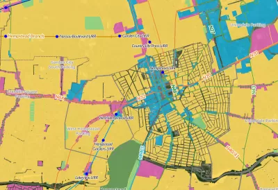
A new interactive ‘zoning atlas’ offers Long Island residents a way to understand the complex web of land use, municipal services, transportation, and zoning districts on the island. As Desiree D'Iorio explains in a piece for WSHU, “It can be filtered to show details like public transportation routes, downtown areas, current land use and special districts for services like sewers, schools, ambulances and sanitation.”
Gwen O'Shea, president of Community Development Long Island, said the tool can help governments and builders understand what type of housing is permitted where and how those regulations intersect with services like transit. “It can help developers see what building opportunities are available, and help officials and housing advocates understand how housing policies impact homeowners and communities.”
FULL STORY: New tool hopes to change how Long Island understands its complex zoning


Barriers to Integration Come Down Slowly in Wealthy, White Suburban Enclaves
Beware of possible code words like "character" and "flavor" when it comes to community resistance to multifamily housing or increased density. Case in point, Garden City, Long Island.

Judge Rules in Favor of Massachusetts TOD Law
The court rejected an argument that the MBTA Communities law, which requires zoning for multifamily housing, is an “unfunded mandate.”

Single-Stair Design Contest Envisions Human-Scale Buildings
Single-stair building construction is having a resurgence in the United States, where, for the last several decades, zoning codes have required more than one staircase in multi-story housing developments.

Planetizen Federal Action Tracker
A weekly monitor of how Trump’s orders and actions are impacting planners and planning in America.

Congressman Proposes Bill to Rename DC Metro “Trump Train”
The Make Autorail Great Again Act would withhold federal funding to the system until the Washington Metropolitan Area Transit Authority (WMATA), rebrands as the Washington Metropolitan Authority for Greater Access (WMAGA).

The Simple Legislative Tool Transforming Vacant Downtowns
In California, Michigan and Georgia, an easy win is bringing dollars — and delight — back to city centers.

The States Losing Rural Delivery Rooms at an Alarming Pace
In some states, as few as 9% of rural hospitals still deliver babies. As a result, rising pre-term births, no adequate pre-term care and harrowing close calls are a growing reality.

The Small South Asian Republic Going all in on EVs
Thanks to one simple policy change less than five years ago, 65% of new cars in this Himalayan country are now electric.

DC Backpedals on Bike Lane Protection, Swaps Barriers for Paint
Citing aesthetic concerns, the city is removing the concrete barriers and flexposts that once separated Arizona Avenue cyclists from motor vehicles.
Urban Design for Planners 1: Software Tools
This six-course series explores essential urban design concepts using open source software and equips planners with the tools they need to participate fully in the urban design process.
Planning for Universal Design
Learn the tools for implementing Universal Design in planning regulations.
Smith Gee Studio
City of Charlotte
City of Camden Redevelopment Agency
City of Astoria
Transportation Research & Education Center (TREC) at Portland State University
US High Speed Rail Association
City of Camden Redevelopment Agency
Municipality of Princeton (NJ)