


A new study by the Trust for Public Land identifies the benefits and fiscal impacts of public parks and open spaces in New York City.
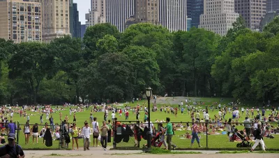
New York City is home to some of the world’s most iconic parks, including the 843-acre Central Park, which offer a wide range of benefits to residents and visitors. But what exactly are the system-wide benefits conveyed by all of these parks? To help answer this question, the Trust for Public Land (TPL) recently released a report entitled The Economic Benefits of Parks in New York City. While previous studies have investigated the economic impact of individual parks, this new report is the first benefit study of the city’s entire integrated park system.
To prepare The Economic Benefits of Parks in New York City, a team of economists, specialists, and research partners used geographic information system (GIS) technology to measure the fiscal impacts of city, state, and federal parks within NYC. The report explains how parks lower healthcare costs for people who exercise there, provide natural air and water filtration, increase property values, and promote tourism while serving as a place for people to connect with nature.
As Sunny Fleming and David LaShell explain in this article on the Esri Blog, the project was no small task. NYC maintains over 48,000 acres of parkland across the city’s five boroughs, making parks a valuable public asset and a critical part of the city’s infrastructure. New York State also maintains important recreational assets like Shirley Chisholm State Park; the National Park Service oversees iconic places like Liberty Island and Grant’s Tomb; and there are many multi-jurisdictional parks like Governors Island and Hudson River Park.
To learn more about the study, including how it is already impacting policy and funding decisions, please read the source article.
FULL STORY: The Economic Value of Parks: NYC


‘Quiet Parks’ Highlight Importance of Silence for Public Health
The initiative recognizes parks and other areas that preserve natural quiet in a world full of noise pollution.

Parks: Essential Community Infrastructure — and a Smart Investment
Even during times of budget constraint, continued investment in parks is critical, as they provide proven benefits to public health, safety, climate resilience, and community well-being — particularly for under-resourced communities.

Palmdale’s Beloved Water Park Gets $2 Million Upgrade
To mark its 20th anniversary, DryTown Water Park has undergone major renovations, ensuring that families across the Antelope Valley continue to enjoy safe, affordable, and much-needed water-based recreation in the high desert.

Maui's Vacation Rental Debate Turns Ugly
Verbal attacks, misinformation campaigns and fistfights plague a high-stakes debate to convert thousands of vacation rentals into long-term housing.

Planetizen Federal Action Tracker
A weekly monitor of how Trump’s orders and actions are impacting planners and planning in America.

San Francisco Suspends Traffic Calming Amidst Record Deaths
Citing “a challenging fiscal landscape,” the city will cease the program on the heels of 42 traffic deaths, including 24 pedestrians.

Defunct Pittsburgh Power Plant to Become Residential Tower
A decommissioned steam heat plant will be redeveloped into almost 100 affordable housing units.

Trump Prompts Restructuring of Transportation Research Board in “Unprecedented Overreach”
The TRB has eliminated more than half of its committees including those focused on climate, equity, and cities.

Amtrak Rolls Out New Orleans to Alabama “Mardi Gras” Train
The new service will operate morning and evening departures between Mobile and New Orleans.
Urban Design for Planners 1: Software Tools
This six-course series explores essential urban design concepts using open source software and equips planners with the tools they need to participate fully in the urban design process.
Planning for Universal Design
Learn the tools for implementing Universal Design in planning regulations.
Heyer Gruel & Associates PA
JM Goldson LLC
Custer County Colorado
City of Camden Redevelopment Agency
City of Astoria
Transportation Research & Education Center (TREC) at Portland State University
Jefferson Parish Government
Camden Redevelopment Agency
City of Claremont