


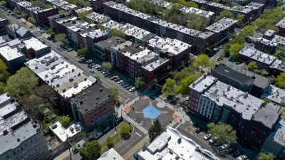
The city voted to reduce speed limits on residential and some arterial streets in an effort to improve traffic safety and reduce the risk of death or serious injury when crashes occur.

As announced in a City of Tacoma press release republished in The Suburban Times, Tacoma’s city council has voted to lower speed limits to 20 miles per hour on residential streets and 25 miles per hour on arterial streets in four of the city’s Neighborhood Business Districts.
“The link between speed and injury severity in crashes is consistent, direct, and especially critical for more vulnerable roadway users. With tonight’s action, coupled with other actions in our Vision Zero Action Plan, our goal of eliminating traffic fatalities and serious injuries by 2035 is in sight,” said Council Member Kristina Walker.
Tacoma passed its Vision Zero ordinance in February 2020, pledging to devote resources to eliminating traffic deaths by 2035. According to the press release, “Speed reduction is one proven strategy to eliminate fatal and serious injury crashes as part of Vision Zero. Lowering speeds improves safety by reducing the frequency and severity of crashes, improves visibility, provides additional time for drivers to stop, and reduces the potential for fatal or serious injuries by lowering impact forces.”
The city plans to roll out an outreach campaign to inform the public about the new speed limits before the law goes into effect in January 2023.
FULL STORY: Tacoma City Council Approves Speed Limit Reduction Ordinance

Vision Zero at Work: Hoboken Celebrates Seven Years of Zero Traffic Deaths
The New Jersey city implemented simple yet impactful changes to eliminate traffic fatalities.

Washington Focuses Road Safety Efforts on Individuals, Neglecting Design
Legislative efforts to reduce traffic deaths could move the needle toward Vision Zero, but state leaders failed to commit infrastructure funds to making structural improvements.
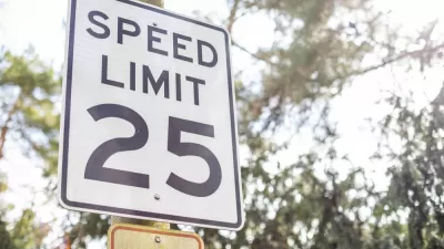
Tacoma’s Lower Speed Limits Take Effect
The city hopes reducing speed limits will help them achieve their Vision Zero pledge.

Maui's Vacation Rental Debate Turns Ugly
Verbal attacks, misinformation campaigns and fistfights plague a high-stakes debate to convert thousands of vacation rentals into long-term housing.

Planetizen Federal Action Tracker
A weekly monitor of how Trump’s orders and actions are impacting planners and planning in America.

Chicago’s Ghost Rails
Just beneath the surface of the modern city lie the remnants of its expansive early 20th-century streetcar system.

Bend, Oregon Zoning Reforms Prioritize Small-Scale Housing
The city altered its zoning code to allow multi-family housing and eliminated parking mandates citywide.

Amtrak Cutting Jobs, Funding to High-Speed Rail
The agency plans to cut 10 percent of its workforce and has confirmed it will not fund new high-speed rail projects.

LA Denies Basic Services to Unhoused Residents
The city has repeatedly failed to respond to requests for trash pickup at encampment sites, and eliminated a program that provided mobile showers and toilets.
Urban Design for Planners 1: Software Tools
This six-course series explores essential urban design concepts using open source software and equips planners with the tools they need to participate fully in the urban design process.
Planning for Universal Design
Learn the tools for implementing Universal Design in planning regulations.
planning NEXT
Appalachian Highlands Housing Partners
Mpact (founded as Rail~Volution)
City of Camden Redevelopment Agency
City of Astoria
City of Portland
City of Laramie