


After homeowners received letters assessing their property’s fire risk, questions remain about the next steps in building fire resilience.
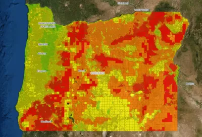
A new wildfire risk map has drawn questions from Oregon homeowners, reports Tiffany Olin for KTVL. Olin writes, “people across Southern Oregon have received letters in the mail from the Department of Forestry classifying their property as high or extreme risk and within the wildland-urban interface.” But the letters have raised questions since they don’t indicate how homeowners should respond. Derek Gasperini, Public Affairs Officer for Oregon Department of Forestry (ODF), said for now, homeowners just need to be aware of the risk to their home.
According to the article, “The Oregon State Fire Marshal will be passing defensible space codes and other regulations by December of this year that are expected to go into effect by April of 2023.” Gasperini said grants will be available to help homeowners pay for defensible space upgrades, which will be required as part of Senate Bill 762, “passed as a response to the 2020 Labor Day fires across the state.”
Planetizen recently covered a proposal to build a community-wide fire perimeter in Paradise, California. The proposal is in part an acknowledgement that fire protection measures can be expensive or impractical for renters, mobile home owners, and other residents in diverse housing types.
FULL STORY: Oregon's new wildfire risk map sparks questions among Southern Oregonians

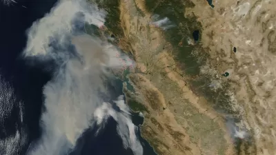
Can We Know Which Homes in California Will Burn?
As the state's worst wildfire season ever refuses to end, an analyst from UCLA considers how land use and building codes determine the location and extent of the damage.
How the West Got Bigger, Badder Fires
Two new books chronicle the origin of U.S. policy on wildfire, the damage that policy has done, and why it’s unlikely to change any time soon.

Rebuilding Smarter: How LA County Is Guiding Fire-Ravaged Communities Toward Resilience
Los Angeles County is leading a coordinated effort to help fire-impacted communities rebuild with resilience by providing recovery resources, promoting fire-wise design, and aligning reconstruction with broader sustainability and climate goals.

Planetizen Federal Action Tracker
A weekly monitor of how Trump’s orders and actions are impacting planners and planning in America.

Maui's Vacation Rental Debate Turns Ugly
Verbal attacks, misinformation campaigns and fistfights plague a high-stakes debate to convert thousands of vacation rentals into long-term housing.

San Francisco Suspends Traffic Calming Amidst Record Deaths
Citing “a challenging fiscal landscape,” the city will cease the program on the heels of 42 traffic deaths, including 24 pedestrians.

Defunct Pittsburgh Power Plant to Become Residential Tower
A decommissioned steam heat plant will be redeveloped into almost 100 affordable housing units.

Trump Prompts Restructuring of Transportation Research Board in “Unprecedented Overreach”
The TRB has eliminated more than half of its committees including those focused on climate, equity, and cities.

Amtrak Rolls Out New Orleans to Alabama “Mardi Gras” Train
The new service will operate morning and evening departures between Mobile and New Orleans.
Urban Design for Planners 1: Software Tools
This six-course series explores essential urban design concepts using open source software and equips planners with the tools they need to participate fully in the urban design process.
Planning for Universal Design
Learn the tools for implementing Universal Design in planning regulations.
Heyer Gruel & Associates PA
JM Goldson LLC
Custer County Colorado
City of Camden Redevelopment Agency
City of Astoria
Transportation Research & Education Center (TREC) at Portland State University
Jefferson Parish Government
Camden Redevelopment Agency
City of Claremont