


Rather than removing the freeway altogether, which the Texas Department of Transportation calls ‘unfeasible,’ the agency recommends burying the road in a billion-dollar, ten-lane trench through the city’s downtown.
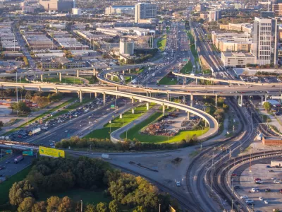
“For many years now, TxDOT has studied the feasibility of removing Interstate 345, which is a 1.7-mile segment of elevated highway that dissects downtown Dallas in Deep Ellum.” But after concluding that “removing the highway is unfeasible,” Joe Cortright writes in Strong Towns, “TxDOT now recommends tearing down the elevated freeway and rebuilding it in a 65-foot-deep trench that will contain 10 travel lanes and cost more than a billion dollars.”
According to Cortright, “If this hybrid approach moves forward, it seems to send a pretty clear message that highway capacity and maintaining commute times are the central priority of the Dallas Metro, not reconnecting neighborhoods or improving the downtown neighborhood quality of life.”
The article describes the original proposal for removing the freeway. “Urban planners Kennedy and Brandon Hancock first pitched the idea of tearing I-345 out, which would free up land the city could re-zone to create a mix of housing, office, and retail. The D Magazine article says TxDOT estimated in 2016 that removal would generate about $2.5 billion in new net value, a ‘significant increase in employment totals,’ and an additional $67.4 million in property tax revenue over 30 years.”
For more details on the TxDOT recommendation, listen to the latest episode of Strong Towns’ Upzoned podcast.
FULL STORY: TxDOT Proposes to Dig a $1 Billion Infrastructure Grave in Downtown Dallas


Columnist to Dallas: Tear Down That Freeway
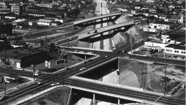
Freeways have been removed before, but if the Texas Department of Transportation decides to tear down the I-345 freeway in Dallas, it would reflect a massive sea change in urban transportation planning.
Will the Reconnecting Communities Program Survive Trump?
A freeway cap in Portland, Oregon is in jeopardy. But the visionary “restorative redevelopment” next door goes on.
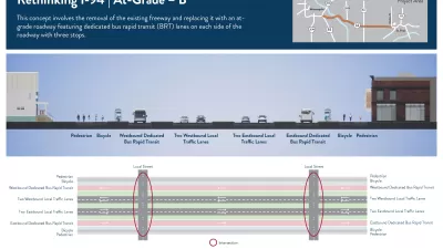
More Options Presented for Minneapolis I-94 Project
Two new proposals for replacing the freeway with at-grade segments offer new visions for the future of downtown Minneapolis.

Maui's Vacation Rental Debate Turns Ugly
Verbal attacks, misinformation campaigns and fistfights plague a high-stakes debate to convert thousands of vacation rentals into long-term housing.

Planetizen Federal Action Tracker
A weekly monitor of how Trump’s orders and actions are impacting planners and planning in America.

In Urban Planning, AI Prompting Could be the New Design Thinking
Creativity has long been key to great urban design. What if we see AI as our new creative partner?

Pedestrian Deaths Drop, Remain Twice as High as in 2009
Fatalities declined by 4 percent in 2024, but the U.S. is still nowhere close to ‘Vision Zero.’

King County Supportive Housing Program Offers Hope for Unhoused Residents
The county is taking a ‘Housing First’ approach that prioritizes getting people into housing, then offering wraparound supportive services.

Researchers Use AI to Get Clearer Picture of US Housing
Analysts are using artificial intelligence to supercharge their research by allowing them to comb through data faster. Though these AI tools can be error prone, they save time and housing researchers are optimistic about the future.
Urban Design for Planners 1: Software Tools
This six-course series explores essential urban design concepts using open source software and equips planners with the tools they need to participate fully in the urban design process.
Planning for Universal Design
Learn the tools for implementing Universal Design in planning regulations.
planning NEXT
Appalachian Highlands Housing Partners
Mpact (founded as Rail~Volution)
City of Camden Redevelopment Agency
City of Astoria
City of Portland
City of Laramie