


The low-slung, car-oriented apartment buildings represent a mid-century solution to a housing shortage and offer valuable lessons for new development.
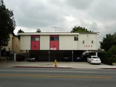
Describing the "aggressively economical" icon of mid-density apartment buildings known as dingbats that pepper Los Angeles from the Valley to the Eastside, Laura Bliss writes that these buildings "were a multifamily answer to that single-family template." These two- to three-story buildings include a carport on the bottom level and generally house six to 12 units. In the 1950s and 1960s, "[t]his new format for affordable multifamily living became nearly as ubiquitous as the single-family tract housing that iconified the much-mythologized Southern California suburban lifestyle."
Dingbats provided "an essential resource for a growing city: Los Angeles County added more than three million residents between 1940 and 1960, thanks to job booms in manufacturing and aerospace, educational opportunities for returning GIs, and the lure of year-round sunshine." Over 700,000 new units sprawled outward as new freeways made the periphery more accessible and the city swallowed up citrus orchards and ranches.
Today, dingbats, many of which are rent-stabilized, offer some important benefits as "a bastion of relatively affordable shelter" in a city facing a severe housing shortage. "Dingbats may also hold the possibility for accommodating further infill: Thanks to recent legal changes, it’s now possible to convert carports into accessory dwelling units, which some owners are beginning to do." These buildings exemplify the mid-century's answer to "missing middle housing" and "tell a story of when the city met the demands of the day with a low-cost, replicable, yet individualized housing form factor."
FULL STORY: How Los Angeles Became the City of Dingbats


L.A. Tenants Hit With Sudden Rent Hikes Under 'Discounted Rent' Loophole
A legal loophole has allowed some Los Angeles landlords to sharply raise rents on apartments that would otherwise fall under the city's rent stabilization ordinance and pandemic-related rent freeze.

How ADUs Can Help Ease the Affordable Housing Crisis
Local policies and programs can encourage homeowner participation and increase the number of ADUs available as low-cost rentals.
Reno Revisits Zoning Reform
After roundly rejecting a proposal to legalize granny flats in 2018, the city council is revising it and other zoning reform proposals that could increase the city’s affordable housing supply.

Planetizen Federal Action Tracker
A weekly monitor of how Trump’s orders and actions are impacting planners and planning in America.

Chicago’s Ghost Rails
Just beneath the surface of the modern city lie the remnants of its expansive early 20th-century streetcar system.

San Antonio and Austin are Fusing Into one Massive Megaregion
The region spanning the two central Texas cities is growing fast, posing challenges for local infrastructure and water supplies.

Since Zion's Shuttles Went Electric “The Smog is Gone”
Visitors to Zion National Park can enjoy the canyon via the nation’s first fully electric park shuttle system.

Trump Distributing DOT Safety Funds at 1/10 Rate of Biden
Funds for Safe Streets and other transportation safety and equity programs are being held up by administrative reviews and conflicts with the Trump administration’s priorities.

German Cities Subsidize Taxis for Women Amid Wave of Violence
Free or low-cost taxi rides can help women navigate cities more safely, but critics say the programs don't address the root causes of violence against women.
Urban Design for Planners 1: Software Tools
This six-course series explores essential urban design concepts using open source software and equips planners with the tools they need to participate fully in the urban design process.
Planning for Universal Design
Learn the tools for implementing Universal Design in planning regulations.
planning NEXT
Appalachian Highlands Housing Partners
Mpact (founded as Rail~Volution)
City of Camden Redevelopment Agency
City of Astoria
City of Portland
City of Laramie