


The New York Times is calling 2010 to 2020 the "Downtown Decade."
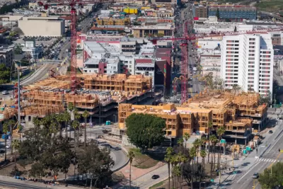
"The recent 2020 census data confirmed earlier estimates that urban counties grew slower than suburban ones over the past decade," writes Jed Kolko. "But more detailed neighborhood census counts reveal that U.S. population density actually rose in the past decade after falling in the previous two decades, a result of faster growth in the most concentrated parts of urban counties."
The fastest-growing neighborhoods were located on the edges of metropolitan areas, explains Kolko. But many downtowns and central business districts grew quickly too. Adding up all the growth, "Americans were more likely to live in the highest-density urban neighborhoods in 2020 than in 1990, 2000 or 2010."
Kolko provides additional insight into the weighted-density measures for neighborhood-level Census data (which are "less skewed by unpopulated land area than conventional density measures," explains Kolko), such as the surprising number of U.S. cities thought of as car oriented appearing in the top 15 of densest cities in the United States (namely, Miami, San José, and Las Vegas).
FULL STORY: The Downtown Decade: U.S. Population Density Rose in the 2010s


News Brief: Census 2020 Population Data
Most of the media commentary that followed last week's release of Census 2020 data focused on trends in the racial demographics of the country and the country's growing rural-urban divide.

Cities Are Back (At Least They Were Before COVID)
The 2020 Census results show that central cities were gaining population to a much greater extent than earlier Census estimates had suggested.

2020 Population Growth Rates for the 50 Biggest U.S. Cities
The Census Bureau released new data on May 27 that includes the first four months of the pandemic. Seattle tops the growth rate at 2.2% from July 1, 2019, to July 1, 2020, while Baltimore and San Francisco land at the bottom with -1.4%.

Maui's Vacation Rental Debate Turns Ugly
Verbal attacks, misinformation campaigns and fistfights plague a high-stakes debate to convert thousands of vacation rentals into long-term housing.

Planetizen Federal Action Tracker
A weekly monitor of how Trump’s orders and actions are impacting planners and planning in America.

In Urban Planning, AI Prompting Could be the New Design Thinking
Creativity has long been key to great urban design. What if we see AI as our new creative partner?

King County Supportive Housing Program Offers Hope for Unhoused Residents
The county is taking a ‘Housing First’ approach that prioritizes getting people into housing, then offering wraparound supportive services.

Researchers Use AI to Get Clearer Picture of US Housing
Analysts are using artificial intelligence to supercharge their research by allowing them to comb through data faster. Though these AI tools can be error prone, they save time and housing researchers are optimistic about the future.

Making Shared Micromobility More Inclusive
Cities and shared mobility system operators can do more to include people with disabilities in planning and operations, per a new report.
Urban Design for Planners 1: Software Tools
This six-course series explores essential urban design concepts using open source software and equips planners with the tools they need to participate fully in the urban design process.
Planning for Universal Design
Learn the tools for implementing Universal Design in planning regulations.
planning NEXT
Appalachian Highlands Housing Partners
Mpact (founded as Rail~Volution)
City of Camden Redevelopment Agency
City of Astoria
City of Portland
City of Laramie