


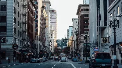
Cities are hotter because of the way we build them, and they could be cooler if we built them differently.

Over the past 30 years, guess what kind of weather disaster has killed more Americans than any other? It’s not hurricanes or tornadoes. It’s not flooding or lightning. It’s heat. And like many other environmental dangers, it disproportionately kills people of color.
As our climate continues to change and heat waves become more frequent, more severe, and longer-lasting, extreme heat events will only become more dangerous. That’s especially true in urban areas, where over 80% of Americans live. The urban heat island effect makes cities warmer than rural areas. The average temperature in a city with over one million people can be as much as 5.4 degrees Fahrenheit warmer than the surrounding countryside. On a calm, clear night, the difference can be as much as 22 degrees.
We can’t control the weather, and in the longer term, even with major climate action from world leaders, some warming is already baked into our climate system. But there is one aspect of extreme heat we can control. Cities are hotter because of how we build them, and they can be cooler if we build them differently.
It’s time for federal regulations to limit how much buildings, roads, parking lots, and other urban features are allowed to heat up the neighborhood. Just as the EPA regulates runoff pollution through the Clean Water Act and air pollution through the Clean Air Act, the agency should also regulate heat pollution through a "cool communities" act.
FULL STORY: As Urban Areas Feel the Heat, It’s Time for National Cool Communities Standards


In Extreme Heat Waves, Cities Need 'Social Resilience' to Help the Most Vulnerable
This summer's heat waves wreaked havoc on physical infrastructure, but also highlighted vulnerabilities in our social support systems.
Redlined Neighborhoods Suffer More From Extreme Heat
The recent heat wave in the Pacific Northwest highlighted how historical inequities still affect the health and well-being of low-income and marginalized communities.
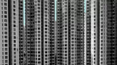
Better Planning Needed to Address Effects of Urban Heat Island in Hong Kong
A recent study reveals the detrimental impact of hot nights compared to hot days, with the region experiencing hotter summers and more hot days due to climate change and the heat island effect.

Planetizen Federal Action Tracker
A weekly monitor of how Trump’s orders and actions are impacting planners and planning in America.

Maui's Vacation Rental Debate Turns Ugly
Verbal attacks, misinformation campaigns and fistfights plague a high-stakes debate to convert thousands of vacation rentals into long-term housing.

San Francisco Suspends Traffic Calming Amidst Record Deaths
Citing “a challenging fiscal landscape,” the city will cease the program on the heels of 42 traffic deaths, including 24 pedestrians.

Defunct Pittsburgh Power Plant to Become Residential Tower
A decommissioned steam heat plant will be redeveloped into almost 100 affordable housing units.

Trump Prompts Restructuring of Transportation Research Board in “Unprecedented Overreach”
The TRB has eliminated more than half of its committees including those focused on climate, equity, and cities.

Amtrak Rolls Out New Orleans to Alabama “Mardi Gras” Train
The new service will operate morning and evening departures between Mobile and New Orleans.
Urban Design for Planners 1: Software Tools
This six-course series explores essential urban design concepts using open source software and equips planners with the tools they need to participate fully in the urban design process.
Planning for Universal Design
Learn the tools for implementing Universal Design in planning regulations.
Heyer Gruel & Associates PA
JM Goldson LLC
Custer County Colorado
City of Camden Redevelopment Agency
City of Astoria
Transportation Research & Education Center (TREC) at Portland State University
Jefferson Parish Government
Camden Redevelopment Agency
City of Claremont