


The regions of the United States that have provided the most hospitable to human life and agriculture on the continent will likely be abandoned in a future altered by climate change, according to this interactive mapping project.
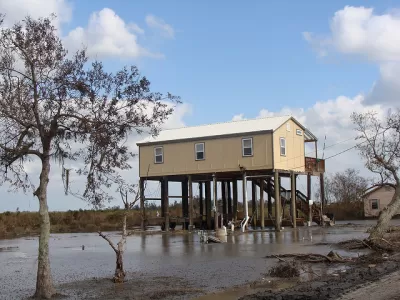
Al Shaw, Abrahm Lustgarten, and Jeremy W. Goldsmith crunch data from a number of recent sources to map out the future of the United States as altered by climate change. "[T]he North American places where humans have lived for thousands of years will shift," according to the authors of the article to introduce the interactive map found at the source link.
The project uses data from a paper published in the Proceedings of the National Academy of Sciences that maps out the shifting future of the human climate "niche," described here at "the regions where temperature and precipitation have been most suitable for humans to live in over the past 6,000 years."
As a result of climate change, "the niche could shift drastically northward. Under even a moderate carbon emissions scenario (known as RCP 4.5), by 2070 much of the Southeast becomes less suitable and the niche shifts toward the Midwest."
Additional research by the Rhodium Group supplies the map's focus on rising temperatures in much of the United States. But there's a catch: "Heat alone, however, won’t determine Americans’ fate. A new climate analysis — presented for the first time here — projects how humidity and heat will collide to form 'wet bulb' temperatures that will disrupt the norms of daily existence."
The outcomes predicted here—including additional factors like sea-level rise, large wildfires, crop yields that will create a cascade of compounding calamities—are nothing short of catastrophic: "profound economic loss" and mass migration in the United States.
Another article by Abrahm Lustgarten supplements the mapping project by exploring in detail the likelihood of a climate migration in the United States within this century. A climate migration is a familiar theme in the news in recent weeks, as fires rage throughout the west and hurricanes stack up in the Atlanta Ocean and Gulf of Mexico.
FULL STORY: New Climate Maps Show a Transformed United States


1.2 Million Climate Refugees and Counting in the United States
Americans are fleeing the effects of climate change by the millions. Expect the number of climate refugees to continue to grow.
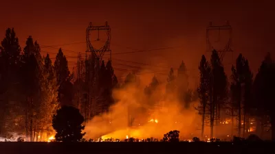
Intense October Heat Wave Raises Fire Risk in California
Unusually high temperatures across the state are prompting power shutoffs and could fuel more destructive wildfires.

California Faces Early Surge in Wildfires
Summer is just beginning, but wildfires in California have already burned more than 90,000 acres.

Planetizen Federal Action Tracker
A weekly monitor of how Trump’s orders and actions are impacting planners and planning in America.

Maui's Vacation Rental Debate Turns Ugly
Verbal attacks, misinformation campaigns and fistfights plague a high-stakes debate to convert thousands of vacation rentals into long-term housing.

San Francisco Suspends Traffic Calming Amidst Record Deaths
Citing “a challenging fiscal landscape,” the city will cease the program on the heels of 42 traffic deaths, including 24 pedestrians.

Amtrak Rolls Out New Orleans to Alabama “Mardi Gras” Train
The new service will operate morning and evening departures between Mobile and New Orleans.

The Subversive Car-Free Guide to Trump's Great American Road Trip
Car-free ways to access Chicagoland’s best tourist attractions.

San Antonio and Austin are Fusing Into one Massive Megaregion
The region spanning the two central Texas cities is growing fast, posing challenges for local infrastructure and water supplies.
Urban Design for Planners 1: Software Tools
This six-course series explores essential urban design concepts using open source software and equips planners with the tools they need to participate fully in the urban design process.
Planning for Universal Design
Learn the tools for implementing Universal Design in planning regulations.
Heyer Gruel & Associates PA
JM Goldson LLC
Custer County Colorado
City of Camden Redevelopment Agency
City of Astoria
Transportation Research & Education Center (TREC) at Portland State University
Jefferson Parish Government
Camden Redevelopment Agency
City of Claremont