


We seem to have an app for everything. Now we have one that walks a viewer through the river’s history from the pre-historic era to the present.

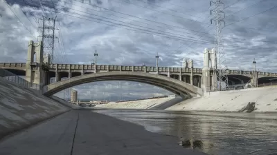
The Los Angeles River is 51 miles long and spans through 17 cities and unincorporated Los Angeles County. The river encompasses an 834-square-mile watershed and flows from its headwaters at river mile 51 in Canoga Park within the city of Los Angeles to river mile zero at Long Beach, where the river meets the Pacific Ocean. The L.A. River was channelized between the late 19th and mid-20th centuries to protect lives and property from flooding as the L.A. region rapidly grew and transformed to a largely urbanized area. Today, one million people live within one mile of the river.
To help folks learn more about and better appreciate the L.A. River, there is now the "Rio de Los Angeles" app. This new augmented reality app was produced by RYOT, a production studio run by Verizon Media that specializes in interactive and immersive experiences, in collaboration with digital studios Vrai Pictures and Superbright. According to Jake Sally, head of development at RYOT, “The L.A. River is amazing, but it’s also hundreds of pages and graphs and data sets, and they are not accessible,” he says. “So can we build a depth of understanding? ... How can people who are in the immediate proximity to the river have a greater understanding of how their small piece fits into the larger context?”
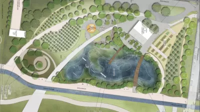
The free app offers a fun, interactive experience for iPhone and iPad that walks a viewer through some of the river’s history from the pre-historic era to the present. Just point your iPhone or iPad at a flat surface and a 3-D map of the Los Angeles Basin loads up on the screen. From there, a menu of options walks the viewer through the river’s history, from the shifting waterway on a broad flood plain to the channelized water body encased in concrete. The app was developed using data from various sources, including historic archives and the L.A. River Index, a research database assembled by River LA, one of the groups involved in the planned redevelopment of the river through an update of the L.A. River Master Plan.
River L.A. has been leading the coordination of an extensive community engagement and outreach process for the Master Plan. This effort was launched by L.A. County Public Works to update the original 1996 master plan, synthesizing more recent ideas for portions of the River and bringing a comprehensive vision to the transformation of the L.A. River.
FULL STORY: The Los Angeles River as you’ve never seen it — in augmented reality


Gehry's Plans for Los Angeles River Restoration Gaining Clarity
Details are emerging in the controversial effort by Gehry Partners, LLP to plan a new vision for the Los Angeles River. So far, however, Gehry Partners seems to have been listening more than plotting or drawing.
An 'Urban Orchard' Next to the Los Angeles River
The city of South Gate, located on the southern stretch of the Los Angeles River, downriver of Downtown Los Angeles, recently published an initial study of the "Urban Orchard Project."
Los Angeles County: It's Time to Update the Master Plan for the L.A. River
The Los Angeles County Board of Supervisors voted this week to begin the processing of updating the 20-year-old Los Angeles River Master Plan.

Planetizen Federal Action Tracker
A weekly monitor of how Trump’s orders and actions are impacting planners and planning in America.

Chicago’s Ghost Rails
Just beneath the surface of the modern city lie the remnants of its expansive early 20th-century streetcar system.

San Antonio and Austin are Fusing Into one Massive Megaregion
The region spanning the two central Texas cities is growing fast, posing challenges for local infrastructure and water supplies.

Since Zion's Shuttles Went Electric “The Smog is Gone”
Visitors to Zion National Park can enjoy the canyon via the nation’s first fully electric park shuttle system.

Trump Distributing DOT Safety Funds at 1/10 Rate of Biden
Funds for Safe Streets and other transportation safety and equity programs are being held up by administrative reviews and conflicts with the Trump administration’s priorities.

German Cities Subsidize Taxis for Women Amid Wave of Violence
Free or low-cost taxi rides can help women navigate cities more safely, but critics say the programs don't address the root causes of violence against women.
Urban Design for Planners 1: Software Tools
This six-course series explores essential urban design concepts using open source software and equips planners with the tools they need to participate fully in the urban design process.
Planning for Universal Design
Learn the tools for implementing Universal Design in planning regulations.
planning NEXT
Appalachian Highlands Housing Partners
Mpact (founded as Rail~Volution)
City of Camden Redevelopment Agency
City of Astoria
City of Portland
City of Laramie