


A new mapping project from researchers at the University of Pennsylvania illustrates the consequences of inaction on climate change.

Sarah Holder shares the work of researchers at the McHarg Center for Urban Ecology at the University of Pennsylvania to map the expected effects of climate change in the United States, calling it the 2100 Project: An Atlas for a Green New Deal.
"The website use a variety of projected and current data sources to sketch out the country’s possible fate, displaying its geography in economic, ecological, agricultural, and ideological terms," explains Holder.
Billy Fleming, the director of the McHarg Center, is quoted in the article saying that the project proves that it’s not to late to make a fundamental difference in the losses the country will experience as the effects of climate change take shape.
The article includes a few examples of maps from the project, on subjects like annual average temperature, mortality, economic effects, and more.
FULL STORY: America After Climate Change, Mapped

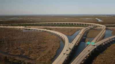
$50 Billion Coastal Master Plan Updated in Louisiana
Louisiana is losing coastal lands, quickly, along with the habitat and economic resources located there. A Coastal Master Plan plots $50 billion in spending to protect the coast.

Climate Change: The Most Vulnerable States Are the Least Prepared
The effects of climate change will vary depending on geographic location, so it's incumbent on states to prepare in their own, specific way. Not all states are taking that responsibility seriously, according to a new report.

Town Hall Spotlights Democrats' Climate Change Proposals
Critics of the earliest Democratic candidate debates have noted a conspicuous lack of substantive and concentrated discussion on one of the great existential threats of the era: climate change. Neglect of the subject could change soon.

Maui's Vacation Rental Debate Turns Ugly
Verbal attacks, misinformation campaigns and fistfights plague a high-stakes debate to convert thousands of vacation rentals into long-term housing.

Planetizen Federal Action Tracker
A weekly monitor of how Trump’s orders and actions are impacting planners and planning in America.

In Urban Planning, AI Prompting Could be the New Design Thinking
Creativity has long been key to great urban design. What if we see AI as our new creative partner?

King County Supportive Housing Program Offers Hope for Unhoused Residents
The county is taking a ‘Housing First’ approach that prioritizes getting people into housing, then offering wraparound supportive services.

Researchers Use AI to Get Clearer Picture of US Housing
Analysts are using artificial intelligence to supercharge their research by allowing them to comb through data faster. Though these AI tools can be error prone, they save time and housing researchers are optimistic about the future.

Making Shared Micromobility More Inclusive
Cities and shared mobility system operators can do more to include people with disabilities in planning and operations, per a new report.
Urban Design for Planners 1: Software Tools
This six-course series explores essential urban design concepts using open source software and equips planners with the tools they need to participate fully in the urban design process.
Planning for Universal Design
Learn the tools for implementing Universal Design in planning regulations.
planning NEXT
Appalachian Highlands Housing Partners
Mpact (founded as Rail~Volution)
City of Camden Redevelopment Agency
City of Astoria
City of Portland
City of Laramie